
SUNDAY is when the Weather starts to turn down hill as our Cold Front drops into WY with Falling Temperatures and Snow Chances likely. Some Weak Upslope is possible in the Bighorns during the Afternoon so expect Higher Amounts in the Mountains

When MONDAY rolls around, we have our Stalled Front staying put along Central & Southeastern WY. Frontal Forcing and Weak Upslope could bring some Upslope for I-80 and Northern CO for the Afternoon. Here's what the NAM is showing (IMAGES BELOW)

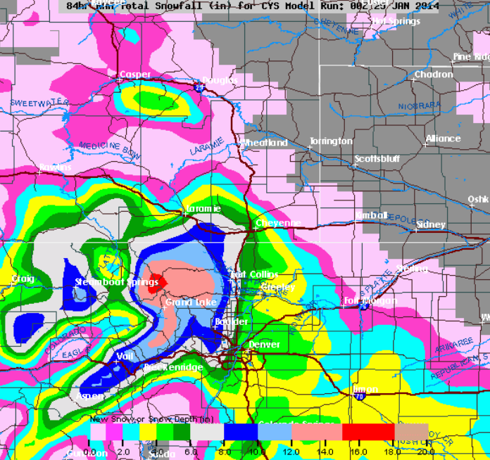
As for the GFS Model, its showing not as much Intensity with the Snow for MONDAY with their Guidance in Southeastern WY:

Here are the NAM & GFS Snowfall Forecast with the Sunday/Monday Storm.
** THESE ARE NOT MY FORECASTS **

<< GFS SNOW AMOUNTS
METEOGRAM: The Bufkit does spit out some Lesser Amounts but I tend to "Agree" more with these before the Snow starts to fall.
Casper ~ 1-1.5"
Lander/Laramie: 1-2.5"
Cheyenne: 1-4"
THOUGHTS: We are still about 48 HRS or so away before the Snow starts but the Model Guidance is likely showing Snow developing on Sunday; but the Monday system is having trouble to verify the Amounts. Though, I do think LIGHT SNOW is possible at this Time along the I-25 Corridor and expected Blowing Snow. The COLD settles in on Monday as well, but that will be discussed on Sunday Night! New Post later in the Weekend.
No comments:
Post a Comment