How was everyone's weekend? Mine was good of watching some great Football and fiddling around the House. It stayed breezy East of the Divide and warm temperatures, too. But, West of the Divide saw snow totals ranging from 6-12" in the Wind Rivers/Tetons and Salt Mountains.
 Lets get to Tuesday's Forecast. Could see a lil light snow chance in the NW Mountains, but much warmer and still breezy East of the Divide.
-Tuesday should be like from Monday, but slightly warmer nearing 60° here in Casper!
Cheyenne should easily break into the 60°s, but much warmer temperatures for Wednesday.
After Wednesday rolls in, a Cold Front will be sweeping in from our North and West and bring chances of Light Snow again in the Mountains. Could see a light snow chance in the Bighorns, but dry and a little windy East of the Divide in the 40s.
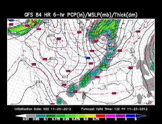
-You can see that Dip in the Northern Plains, which is a Trough, sending down cooler Temperatures. Any Snowfall will remain to the Dakota's and Northern Minnesota.
- Just remember, last Turkey Day was a cold one and at least we can enjoy a 'seasonable' one. Last week, it was a warmer solution, but that Trough was digging quite fast from runs this past weekend...meaning cooler temperatures.
BLACK FRIDAY...It'll be cool to start off around Midnight, but Winds will begin to pick up from the South and West as the Trough leaves us to the East and a Ridge begins to warm us back up near 50° on Friday Afternoon.
-GFS, shown here, is a little warmer than the NAM, but should bundle up as the winds will keep that wind chill just above Freezing.
Don't enjoy the weekend so fast for Saturday as we'll climb in the mid-50's possibly again, but our next Winter Storm is approaching as we'll see moisture coming from our West.
-COLD Canadian air invades into the Inner-Mountain West as a Front sags in with the Moisture filtering through. Big Snow's are expected again in the Western Mountains and then a band comes into East of the Divide later into Sunday Night.
NO Exact snow amounts as of yet, which is still way too far away to call and How cold we could get, but this is probably the same setup from last Week's snow system.


No comments:
Post a Comment