We made it through this week and what a week it was. From a Cold start on Monday and Windy conditions..then a gradual warmup in the 40°s and then to 57° on Friday here in Casper! On the other Hand, if your farther West in Riverton and other places, much cooler Temperatures resided in the basins where Snow filtered in on Tuesday and Wednesday.
Lets get to this upcoming Weekend. Same Setup from Friday for your Saturday. If your Casper and points East, 50°s will remain in control through Sunday and maybe longer after that...I will not be surprised if Far East WY will touch the 60°s. I mentioned that last night, and Torrington hit 65°!
NAM Temps at 2PM shows that sharp contrast like I told you. It may not even get out of the 30°s West of the Divide, where they may see some wintry weather
Sunny/Breezy and Warm East of the Divide, BUT, a new batch of moisture will increase from MT/ID later in the day and ongoing for Sunday.
GFS is handling this snow for Western WY a little better with their consistency. Snow Amounts could vary from 8-12" in the Higher Elevations and maybe a little more if enough energy comes in. It all dies after the storm moves East of the Divide past the Basins.
 NOW, Turkey Day is still a go for Dry Conditions, but 2 runs of the GFS (18/12z) were concerning me for late in the Evening around 11PM.
 (18z GFS TURKEY Night at 11PM)~ We'll stay Dry/Warm in the lower 50°s here in Casper, but a Trough will dig in from the West and create some energy and moisture for East of the Divide.
Totally threw me off as I saw the 12z today and then the 18z Run earlier tonight.
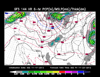
NOW, look at this!..Here is tonight's 0z GFS Run Model!
-WHERE IS THE MOISTURE??? We are Dry throughout Turkey Day, but something else is coming to me. GFS has that Trough farther North and carving our Temperatures too.
GFS's run tonight is going with the EURO on this one and has cooler temperatures in mid-upper 40°s on Thursday.
Thought's on Turkey Day: For Now, I am still going for lower 50°s and Dry through the day and evening. It's just one model and in consistent with their cold air or Precip.
I pick through these Models and Dissect them this Weekend and will have a better grasp when Monday comes around. As for now, My main focus is the Western WY snow for Sunday through the Evening.


No comments:
Post a Comment