Good Monday Evening OR Early Tuesday Folks,
After our Cloudy start to Monday, we improved the Temperatures in the Lower 70°s for Central WY as the Sun came out.
TUESDAY: Still expect a Nice Afternoon as we'll climb in the Low to Mid 70°s under Breezy, Dry Sunny Conditions. As Evening Progresses, chances of rain Increase as the early effects of the storm will impact NW Wyoming.
WEDNESDAY: Overall, it'll be another Seasonal, Dry, but Breezy Afternoon for most of Central & Eastern WY as our Cool Front will arrive. A rapidly developing area of Low Pressure will begin to form in Eastern WY (996/992mb) as it'll provide a Rain Chance for Central WY. However, the Intensity of the Precip varies from all Three Weather Models. PLUS, Wherever that Rain/Snow Line is hard to determine for Western WY.
Thoughts: I think the Higher Elevations could see periods of Moderate Snow as a Rain/Snow Mix could be sporadic as the Cooler Air ushers in from the West through the Afternoon and Early Evening
(0z NAM valid for Wednesday @ 6PM)
** With this Strong Low, some parts of Central WY could see a few Storms ahead of this Front.
LATE NIGHT: Here is where it gets Tough... the NAM Model wants to keep WY dry while the EURO & GFS Model shows a little more Moisture to see a Mix in the Bighorns..but Rain for rest of Central WY.
THURSDAY: THIS will be a Critical Day of what could occur. What is Forecasted to Occur is a Back Door Cold Front (Secondary Front) sliding in from the North dropping South. How COOL our Actual Temps are will reflect on how fast they could drop later in the Evening to differentiate What Precipitation "Who" could see "What".
(0zGFS valid for Thursday @ 6PM)
-- GFS (shown here) & the EURO Model are Showing Two areas of Low Pressure forming to the South in CO & UT as light Rain could develop 1st in Central WY & Snow transitioning for Western WY.
LATE Thursday: The newest GFS that came out showed a Heavy Swath of Precip on-top of Central WY. Expect that changeover to occur to a Mix and the Higher Elevations East of the Divide (Wind Rivers, & Casper Mtn) could see some Snow developing.
FRIDAY:
AM: As we wake up, all Models are showing the Upslope Effect take shape as a Low will deepen in NE Colorado/Nebraska area. The NAM shows the storm with some "lighter snow" trying to fall. HOWEVER, its a different ball game from the EURO/GFS Models.
I think Temperatures will play a large factor of who will see what as we'll be Very Close to the Freezing Line. Our Precipitation could "Band" and if that does, expect some Intense Snow/Mix/or Rain. Casper Mtn could see some intense Snow IF this Occurs.
(0zGFS valid for Friday @ 6AM)
HEAVY Precip along I-25 as you can see and Moderate Snow is possible for Western WY. But Look, Still DRY for Cheyenne & the Laramies. Our Spinning Low is near Greeley, CO wrapping up and sitting on-top. A Weak Low in UT/CO could spark off more moisture for SW Wyoming.
PM: This Low could stall out and keep much of Central WY unsettled through the Day with a Rain/Snow Mix all day with Cool Temperatures and light Snow likely in the Mountains. SOUTHEAST WY, I think when we approach Friday Afternoon > Overnight, this is where our greatest chance of seeing some type of Rain/Snow/Mix to all Light Snow event could occur.
SATURDAY:
ALL of WY should Dry out but the Temperatures will stay below Average maybe in the 60°s for High's.
NOW... This is the Section where Many just want to Fumble Through and know..
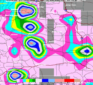
SNOW AMOUNT POTENTIAL:
** PLEASE Remember that some of the Amounts could be overdone, that some could mix in with Rain **
- HERE is the NAM Model Amount that is valid through Friday @ 6AM:
-- A little less but you can see how much it is for your Area with the Legend showing you the Color Range in Inches.
- HERE is the GFS from Earlier Today through Saturday Morning:
- One More SNOW Map..This is our In-House RPM Model that is valid until 6PM THURSDAY:
--Already, some parts are capable of seeing over 10" in the Higher Mountains...and this does NOT include the Thursday Night and so-forth Snowfall.
THOUGHTS: It's Still Too Early in the Ballgame to fine-tune this, so it will likely Change but the Potential Exists for Accumulation in Central WY and Higher Amounts in the Mountains.


No comments:
Post a Comment