THURSDAY AM to 6PM: As we wake up, much of WY will stay Dry and could see some peeks of Sun at times. This is the Critical time frame of whether what kind of Precip many of us could see as we near Overnight Thursday of when that "Transition" begins. Here are the Temps I am going for:

< You see a Temperature Difference drastically from Casper to Riverton, since I think it'll take a longer time for the Basins to warm up. We'll stay dry until our "2nd Punch" arrives as a new Cool Front will usher in another drop of Temperatures.
THURSDAY PM to MIDNIGHT: NOW, this is when Conditions will deteriorate as our Cool Air will sink in as that New Low will form from our South in CO bringing that Upslope effect of Moisture. However, the Newer Weather Data from Wednesday Evening is still Different in Temperatures but getting that better consistency of the Precip placement. I'll show you what I am seeing:
 |
| GFS @ MIDNIGHT THURSDAY |
<< GFS this Evening shows ALL Rain for Casper when Midnight rolls around as our Low intensifies in Eastern CO.
- Riverton/Lander at this time will be a little cooler than Casper, but I think they'll stay mainly rain and maybe some Frozen Precip may mix in at times.
- Bighorns/Owl Creeks/Wind Rivers could see some Mix Precip to Snow with heavy Intensity as our Low explodes to the Southeast.
- NOT SHOWN, but the EURO Model was consistent with the GFS on the Temps & Precip placement.
 | |
| NAM @ MIDNIGHT THURSDAY |
<< NAM this Evening was actually cooler than the morning run from Today.
-Plus, the NAM is different in Temperatures than the GFS...Why? They are about a few degrees COLDER. This means that the Precip could Transition from Rain to a Rain/Mix faster...plus sooner time to see the Snow chances to pile up.
-- ALL the Mountain Ranges should start seeing Moderate to Heavy Snow at times.

<< Our In-House RPM run is showing that Change-Over from RAIN to SNOW around the Overnight Hours around 1-3AM Early Friday Morning for much of Casper, Riverton, & Lander; while it'll transition earlier for the Mountains.
With all the Snow Potential for the Mountains, we are still continuing the WINTER STORM WATCH for many of the Mountains; also the Foothills of Lander from Thursday Evening to Noon Friday.

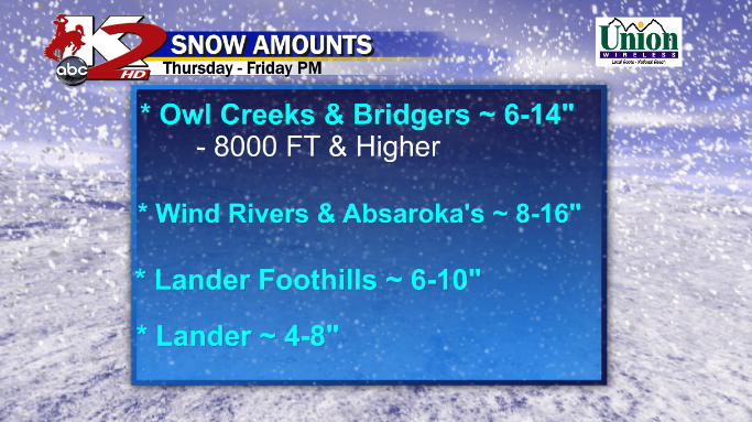
For the Areas that are Experiencing the Winter Storm Watches, Here are the Amounts I am going for at this Time. This could be subject to change based on the Intensity of the Storm and the arrival of the Transition from the Rain>Mix> all Snow.

<< NAM by 6AM Friday shows a cold ( 546 Thickness) along and West of Casper. IF this verifies, we have SNOW for Casper and all of Fremont Co too. Snow will be Light, but maybe Moderate at times if any banding develops.

<< GFS by 6AM Friday shows a "slightly" warmer ( 552 Thickness) on top of Casper..and cooler to the West in Riverton/Lander.
-- Casper: IF this verifies, we'll see a Snow/Mix through the Morning and Casper Mtn probably will get that Snow Chance
--Riverton/Lander: IF this verifies, a slow transition to ALL Light Snow and Heavy Snow continues in the Mountains..while Cheyenne could see cold Rain.

SNOW POTENTIAL MAPS:
** Since this will be a very Heavy/Wet/Snow, I am using a 10:1 Ratio 1" Rain = 10" Snow & may have to factor in the Rain from Night before..so may have to drop an Inch or Two

** NAM SNOW AMOUNT**
-- IF the Storm Trends the "Cooler" NAM, SNOW galore for much of Central WY.
Casper: 3-8"
Riverton: 2-5"
Lander: 5-12" 12 being near the Foothills of the Wind River's.

Casper: 1-3" Casper Mountain 2-4"
Riverton: 1-4"
Lander: 3-8"
ONE LAST THING:... The Meteogram I use to Forecast Amounts...this takes a Range from various Models
Casper: 1- 4.5"
Riverton: 1 - 5.5"
Landeer: 4-8"
No comments:
Post a Comment