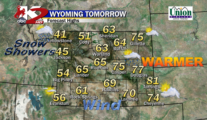
Quite a warm Tuesday for much of Central & Eastern WY as they experienced winds increased through the afternoon propelling the Temperatures in the Mid to Upper 70°s.
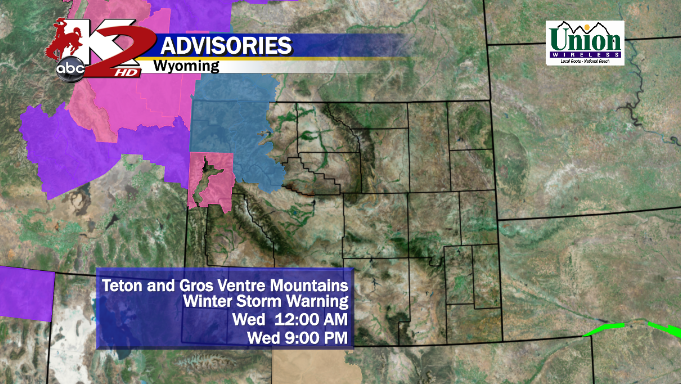
WEDNESDAY: A Cool Front from the North & West will slide in as it progresses Eastward through the Afternoon, so the Temperatures could reflect on the timing as the Front passes. Shower chances & breezy weather continues for much of Central WY, Dry/Warm E of the Laramies, AND SNOW Showers (some Light to Moderate) in Intensity or a Mix could continue for Western WY.
I mentioned how there could be a 1-2 Punch, well this 1st Rd of Cool Air will arrive by Noon for parts of Central WY

 |
| 0z GFS valid for 12AM Friday |
<< GFS by Late Thursday has a Strong Low in NE Colorado (1000mb) with Moderate to Heavy Precip developing in Central WY as our Front pushes South. NOW, if this System trends with this one, Casper could see more of a Rain chance while Riverton/Lander could see that changeover to a Mix.
I think the Mountains could see a mix of that Snow in the Bighorns and ALL Snow for Bighorns and Western WY, again.

Here's Why:
1) The Low is a smidge East and Not as Intense with the Low...only at 1004mb. Remember, the Deeper the Pressure, more Intense the Storm is.
2) NAM is Colder than the GFS for Central WY & this Evening's Run is colder than the Morning Run. Maybe this is a sign of what is to come?
3) NOT as much Precip for Casper area, but enough for the Wind River Basin/Mountains. So we could see that change over fast from Rain>Mix>Lgt Snow? HEAVY Snow is Possible for the Mtns.
FRIDAY AM: From Midnight through the AM, we'll slowly watch the Colder Air usher in through Central WY and watch a Band of Heavy Rain/Mix/Snow develop in this Area. Again, the NAM is Much Colder than the GFS and I won't be surprised if we see SNOW developing by Rush Hour for the Morning Commute.

I think this is when that "ALL SNOW" alert can come into Play if the Storm works in with the NAM. Light Amounts indeed for the Lower Elevations of Central WY with Higher Amounts in the Mountains.
-- Not showing it, but the GFS is still a tad 'warmer' than this NAM Run at 6AM Friday.
FRIDAY PM: Models don't vary once again on the Exiting of the Storm System. By 6PM, the NAM pushes the storm South & East of Central WY as Cheyenne gets it while a New Low forms giving them that chance of Rain/Snow/Mix. HOWEVER, here is what the GFS thinks (IMAGE BELOW)
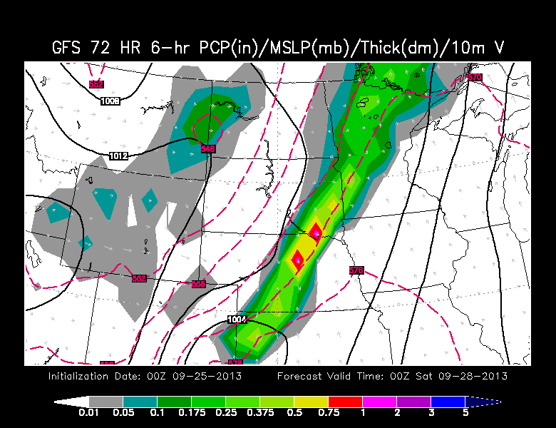
By 6PM Friday, some residual moisture lingers in WY to give us that chance of some Mixed Precip, while Cheyennes stays drier than forecasted.
SATURDAY: The Storm travels East toward the Dakota's and Plains leaving us Cool but Dry as the Sun should come out and melt any snow thats on the ground as Temperatures will climb only in the 50°s
SNOW AMOUNTS from Different Weather Sites:
* When I forecast Snow Amounts, I "accumulate" lots of data from various sites that spits out different observations.
 | |
| PENN ST E-WALL NAM HI RES SNOW POTENTIAL THROUGH 60 HOURS |
-- HERE is the NAM Hi-Res Model showing you the Heavier Snows in Western WY and the Mountains showing about 6"+ in Bighorns & nearly a Foot or Higher elsewhere.
- Casper Mtn: 4-6"
- Lower Elevations: Anywhere from a Trace- 3"
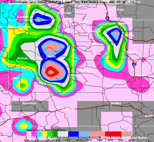
<< HERE is the GFS Snow Amount. I included the Roads to help you out.
** Remember, the GFS, was a little "Warmer" than the NAM for the Casper area, so thats why there is lesser amounts of snow for them and in the Riverton area. BIG Snows for the Mountains where over a Foot is expected.
THOUGHTS: With the Models still not consistent from one Run after another OR not agreeing with each other, its still a Toss-Up of what is expected. I think as we near the 'under' 36 Hour mark of the Snow Event for Central WY, Thursday will be a better day of having a Better Knowledge of what the Heck is going on.
BIG Storm for some in Late September.
-MS
No comments:
Post a Comment