Friday, November 30, 2012

WEEKEND SNOW STORM FOR WESTERN WY

Friday...whew!...we are done for the week guys!  Now, for the majority of us, East of the Divide, hope you held onto your caps since it was breezy and balmy. 

Rest of the Weekend for East of the Divide (Casper/Riverton/Cheyenne, etc.)
  -- Continuing with the Balmy and Mild Temperatures that will remain Unseasonably Warm that'll be 15-20°s Above Normal.  PLUS, winds will be over 20mph + sustained, but BLUSTERY for Sunday as the Front approaches.  Could see High Wind Warnings in effect.


SNOW TALK: 

Snows from Friday Night and Early Saturday is about to tapper off and here are the Unofficial Reports I have seen so far:

Jackson Hole Ski Resort ~ 3-7"
Brooks Lake ~ 3" 
Togwotee ~ 1-2"

Next Wave of Moisture arrives here later in the day on Saturday and sticks with us through the Evening and Overnight hours.

--GFS is a little more South than the NAM with their Snow into Lincoln Co. and stretching up in the YNP region.  Could see a little big slide into the Wind River's.   

--We'll see how this pans out.


SUNDAY looks to be the best Moisture-Laden disturbance, meaning more intense snowfall rates.

-- Bright Greens show very strong Precipitation and pending on how warm we get in the Valleys, it could start as a Rain>to a Mix> and then ALL Snow as the Front creeps in. 

--GFS is better than the NAM with Light Snow in the Bighorns and Sierra Madre's and could clip in to SweetWater County. 

** As for Casper/Riverton-- Remaining Blustery and Dry through 11 PM Sunday Night.


MONDAY MORNING:
--See how there is 'split flow'?  One band of Moisture is to the North in the Bighorns and approaching the Black Hills and the OTHER is along I-80?  That Strong SW flow of winds could rip the storm apart as it crosses East of the Divide, limiting the Snow Chances for Casper.

--All of this should deteriorate when Monday Mid-day passes.


TOTAL SNOW AMOUNTS from the RPM Model:
Some could be enhanced with some Rainfall, keep in mind.

I'll be Updating this Saturday Afternoon and see where we are with Snow Amounts and Tally's!


As I Mentioned, some could see FEET of Snow. 

Thursday, November 29, 2012

FRIDAY'S OUTLOOK and FEET of 'Snow'?

Lets get right down to it 'Folks.

Nothing too special for East of the Divide except Carbon-Copy temperatures on tap like it has been for the past several days in the 50°s and nearing 60° in SE Wyoming.

As for West of the Divide, a Different story; periods of Snow.  Last Night's was a weak event with a Few Inches fallen around Old Faithful.

Here is Friday Night's Setup:

--After copious amounts of Rain in the valleys of Idaho, comes the Deluge of Heavy snow for Friday Night.  Several Inches are possible with this wave, but its not going to be a very cold and powdery snow.  Just a thick, wet heavy snow.


May squeeze out some Moisture from this for the Wind Rivers and into Sweetwater County, but everywhere else in WY is very Dry.

Here are the Snowfall Accumulations for the next 72 Hours..Some is a little overdone, as some of this could be in the type of Rain.

- I mentioned tonight about 'gargantuan' amounts and Earlier how Western WY is in Winter Storm Watch?   Here you go.  Bighorns could see at least a few inches when Sunday Night rolls around, though. 

FEET OF SNOW...  Somewhere between 2-3' is possible.


I'll Talk more about this later on Friday! 

Wednesday, November 28, 2012

THURSDAY's OUTLOOK

Thursday looks to be another Carbon-Copy day from Wednesday in regards to the Temperatures.

As for the Precipitation, a Wintry Mix will drape through Western WY for the Overnight Hours, but then a change to all snow will slide in and start filtering in all of the WY Western Ranges before dawn. 


--RPM Model at 3AM shows the snow to start filling in, moderate intensity at times, in the Wind Rivers and Tetons. 

NOT a big snow, but could cause some slick spots if going over the Passes.


Snow continues in the early Afternoon hours, but should taper off after 3PM.  A few flurries could still fly around and linger.


As I mentioned Above, Not a Big Snow with this Disturbance.  Through this week, we will have several arrive from our West.  Our Next one should arrive by Friday Night..as for this storm, here are expect totals generated by the RPM Model.

Tuesday, November 27, 2012

WEDNESDAY OUTLOOK

  Much Warmer for our Tuesday for Central/Southern WY as the upper 40°s took shape and far Eastern WY were felt in the 50°s.

Here is what you can expect for Wednesday:

Temperatures will try to climb in the Middle 50°s in Central WY, but 60°s could be felt in SE WY around Cheyenne and Torrington.

As Wednesday will 'wind' down to a close, A new system will approach Western WY late Wednesday Night into early morning hours on Thursday.  Don't expect too much with this one, as the dynamics aren't looking too impressive as the main impacts could be a few inches of snow in the Higher Elevations.


--No Impacts for East of the Divide for WY, as the system will fall apart and clouds will filter in on Thursday.  Could be a 'touch' cooler with that patchy cloud cover.


As I Mentioned, not a Big snow, but Teton Pass could see maybe 2-4" and a few inches elsewhere in the white.


HAVE A GREAT TUESDAY & I will start dissecting our 'lack of snowfall' beginning tomorrow.

-Mike

Monday, November 26, 2012

Tuesday's Outlook

What an abnormal Monday some of us in WY had with Freezing Fog here in Casper and points out toward Douglas and up North along 25!    When you have Low Hanging Clouds or a disturbance moving in, with Below Freezing Temperatures, and Calm Winds...you get Freezing Fog. 


Dry day all across WY for your Tuesday.  I think the next system to start 'approaching' the Western side of the state will slide into Wednesday Night and should only affect West of the Divide in WY.


--Ridging will start taking shape as an Amplitude Ridge will ramp the moisture farther North and West of us.  While we will see the warm up with the Ridge, folks to our East is seeing the cooler weather pattern with that Trough digging in the Ohio Valley.


With that Ridge of High Pressure building in our neck of woods, Temperatures will warm back up.

Central and Eastern WY could see Temperatures in the upper 40°s and maybe middle 50°s in SE WY. 

*Note how the Northern 1/3 of the State is in the colder Blue colors?...That area will have a higher depth of snow, keeping the Temperatures in the 30°s.


Why the Warmup with the Ridge?  Well, SW flow will increase with (Warm Air Advection) OR Warm wind blowing wind. Wind Corridors along I-80 and up to Casper should stay relatively breezy with winds over 20mph sustained through the day.

Sunday, November 25, 2012

Sunday Snow Update

Western WY received several inches of snowfall late last night and into Early Sunday.

Here are the snow totals as of 5PM Sunday:


LOCATION                             SNOWFALL

BIG HORN COUNTY...
 BONE SPRINGS DIVIDE SNOTEL...        7 INCHES.
 SHELL CREEK SNOTEL...                7 INCHES.
 BALD MOUNTAIN SNOTEL...              4 INCHES.

FREMONT COUNTY...
 BROOKS LAKE LODGE...                 5 INCHES.
 BURROUGHS CREEK SNOTEL...            4 INCHES.
 LITTLE WARM SNOTEL...                2 INCHES.
 CASTLE CREEK SNOTEL...               3 INCHES.

JOHNSON COUNTY...
 BEAR TRAP MEADOW SNOTEL...           6 INCHES.
 HANSEN SAWMILL SNOTEL...             5 INCHES.
 LITTLE GOOSE SNOTEL...               4 INCHES.

PARK COUNTY...
 EVENING STAR SNOTEL...              11 INCHES.
 BLACKWATER SNOTEL...                 4 INCHES.
 WOLVERINE SNOTEL...                  3 INCHES.
 YOUNTS PEAK SNOTEL...                4 INCHES.
 MARQUETTE SNOTEL...                  3 INCHES.
 BEARTOOTH LAKE SNOTEL...             3 INCHES.

SUBLETTE COUNTY...
 KENDALL RANGER STATION SNOTEL...     6 INCHES.
 GUNSITE PASS SNOTEL...               7 INCHES.
 TRIPLE PEAK SNOTEL...                1 INCH.

TETON COUNTY...
 GRAND TARGHEE SNOTEL...             16 INCHES.
 GRAND TARGHEE-CHIEF JOSEPH...       11 INCHES.
 JACKSON HOLE-RENDEZVOUS BOWL...     13 INCHES.
 GRAND TARGHEE SKI AREA...           11 INCHES.
 BASE CAMP SNOTEL...                  9 INCHES.
 GRASSY LAKE SNOTEL...               12 INCHES.
 TOGWOTEE PASS SNOTEL...              6 INCHES.
 JACKSON HOLE-RAYMER...              11 INCHES.
 JACKSON HOLE-MID...                  9 INCHES.
 TOGWOTEE MOUNTAIN LODGE...           5 INCHES.
 SNOW KING SKI AREA...                4 INCHES.
 SNAKE RIVER STN SNOTEL...            4 INCHES.
 PHILLIPS BENCH SNOTEL...             2 INCHES.
 JACKSON HOLE-BASE...                 3 INCHES.
 GROS VENTRE SUMMIT SNOTEL...         1 INCH.

WASHAKIE COUNTY...
 POWDER RIVER PASS SNOTEL...          7 INCHES.
 MIDDLE POWDER SNOTEL...              4 INCHES.

YELLOWSTONE NATIONAL PARK...
 TWO OCEAN PLATEAU SNOTEL...          7 INCHES.
 LEWIS LAKE DIVIDE SNOTEL...          8 INCHES.
 PARKER PEAK SNOTEL...                6 INCHES.
 SYLVAN LAKE SNOTEL...                6 INCHES.
 THUMB DIVIDE SNOTEL...               3 INCHES.
 CANYON SNOTEL...                     4 INCHES.
 SYLVAN ROAD SNOTEL...                7 INCHES.

-- As for Casper, Dry and Mild in the lower 40°s on this Sunday, but we could still see some light snow fall. Not a big snow, maybe an Inch or a Two.  Casper Mountain, could see a few inches.

Here is what the Radar at 5:30 PM looks like:

--Low Pressure is still spiraling through and the bulk of the Snow is where the Winter Weather Advisory remains (Big Horns)  where they can see a few more inches when all is said and done with.  

Saturday, November 24, 2012

SUNDAY 'SNOW' DAY

Snow is-a-coming!  Remember folks, BUS BUS BUS (Brings Us Snow)

This past week has been very mild and Warm with breezy conditions, including our Turkey Day in the Middle 40°s here in Casper.  It was a very Warm Parade evening tonight in the 40°s, but it was great seeing you all out there as I was passing out Candy Canes and Peppermints.

Okay, lets get to the Meat and Potatoes~  The Snow!~

Low Pressure swinging from our Northwest will bring a wave of Snow and Cold Air from Canada beginning now (Saturday Night) in NW WY and will filter through the rest of WY on Sunday.  Winds will shift from the Southwest to the North and Northwest.

Here is what the Surface Map could look like at 11AM Sunday.  High Pressure will take shape behind the snow and could plum-it our Overnight Lows in the Teens again.  Should start seeing snowfall by mid-afternoon here in Casper and could last through Monday.  Not a BIG snow, but highest amounts will stay in the typical spots of the Higher Elevations.


Winter Weather Advisories are out in the Bighorns and in the Southern Range just West of Kayce.  YNP, Gros Ventres, Tetons, Absaroka's are under the advisory.

NWS out of Riverton Winter Weather Advisory Critera:  

Lower Elevations/Valley (Teton Valley) 3-6"
Highest Elevations~ 6-12"


Here is what the NAM Hi-Resolution snowfall map that is out for 60hrs has:

Only Difference I see is that they added the Wind Rivers with higher snowfall rates and in the Tetons.  As the Low Pressure slides farther East of the Divide, the Bighorns will get its share of the Snow of 3-6".  
**Casper Area, maybe an inch or two.  BUT, Casper Mountaint could see just a little bit higher than that of 2-4" and down along the Northern fringes of the Laramie Range in Southern Converse and through Platte/Goshen Co. (Wheatland/Torrington)
**Black Hills~ Could see a Few Inches in the Sundance area and just East of Newscastle as the Low tracks  Sunday Night.

GFS from Earl Barker's Page 0z run: 
 This is for 120-HR's out and now how Central WY is scarce in the Basins (Riverton/Worland).

-6-12" for Absaroka's, Tetons, Gros Ventres, WY Range, and even East into the Bighorns.

-GFS has maybe 3-4" for Wind River's though.  All depends on whether we'll get that different wind flow to help the Wind Rivers in a good snow or not.  Not a decent upslope for Casper; only painting Dusting to 2"


And from the Same Site, but for the NAM 0z Run:

-BIGHORN Country, This run is for you, but some of this could be with the rain mixed in.

Casper-...Its like nails on a chalkboard..WHERE IS THE SNOW?  We average 12" of Snow for November..

-Forgot to mention, it may not even be a Southern WY snow, due to the track of the Low Pressure moving more North and East of the Laramies.  Include, its hard to get something over the Rattlesnakes and Green Mountains, too.


FINAL THOUGHTS:  Though most of the snow hasn't fallen yet or the bulk of the snow here in WY, still time to tell on this one and the track could shift a more West making Central WY and SW WY to see a little more snow.  The Winds could change and also the Low could track to make a hopeful 'upslope' effect here in Casper...

I'll Update on the progress on Sunday!  Stay Tuned!

Tuesday, November 20, 2012

Wednesday's Outlook and Turkey Day Forecast

A Beautiful Tuesday, but still breezy for the majority of us here in WY.  Expect the same conditions, but a touch Warmer and Windier as an approaching Cold Front from the West filters in.

Lets get to the Warm Temperatures 1st:

Lines denote just where Temperatures could be for our Wednesday.  Casper could creep into the 60°s, but if you saw them today, expect the same for Wednesday.

Extreme SE WY, such as Torrington,  may touch the 70°s.  Majority of the Warm Air will remain in the Great Plains in NE down to Texas.


Other Story to discuss, besides the Warm Temperatures, will be the Windy Conditions. Wind Corridors along the:  Wind Rivers, I-80 and up to Casper, in NW WY around the Mountains will be the portions of seeing those Windy Conditions in advance of an approaching Cold Front later Wednesday Evening.


--  These are sustained Winds around 1PM during the max heating of the day and the Reds show over 30..and Gusts up to 50-60.  Hazardous Travel for the families so hold onto the steering wheel very firmly.


Besides the Temperatures, Wind...now its time to talk about the other side of the state...SNOWY SIDE

Not a lot of Dynamics with this, but some Isentropic Lift (Over running of moisture on top of moisture) will give some of the Higher Elevations a good dose of snow..should expect the same amount or so in the same spots from this past Sunday's system...Take A Look!

-Wind Rivers, Salt Mountains, Absarokas, Tetons will get majority of the Snow..BUT, if the system takes a GFS Track for Early Thursday, BIGHORNS may get a couple Inches.


And here is the Weather Map from the GFS, who is a little more aggressive with the QPF.  Should see some Light to Moderate Snowfall by Wednesday Evening in Far Western WY and filtering in by Midnight. Just remaining cloudy and windy with cooler air filtering through East of the Divide. FYI, A High Wind Watch will be in effect thru Late Wednesday.


As for the Rest of the Day for Thanksgiving, Models have been hinting 'cooler' Temperatures and nearing Seasonable as High's may hold in the lower 40°s.  Staying Dry though, but a snowflake could fall in the Higher elevations around the Bighorn's. 

Monday, November 19, 2012

Much Warmer for Tuesday, slightly Cool now for Tom Turkey Day

GOOD EVENING Folks!

How was everyone's weekend?  Mine was good of watching some great Football and fiddling around the House.  It stayed breezy East of the Divide and warm temperatures, too.  But, West of the Divide saw snow totals ranging from 6-12" in the Wind Rivers/Tetons and Salt Mountains.

Lets get to Tuesday's Forecast.  Could see a lil light snow chance in the NW Mountains, but much warmer and still breezy East of the Divide.

-Tuesday should be like from Monday, but slightly warmer nearing 60° here in Casper!

Cheyenne should easily break into the 60°s, but much warmer temperatures for Wednesday.


After Wednesday rolls in, a Cold Front will be sweeping in from our North and West and bring chances of Light Snow again in the Mountains.  Could see a light snow chance in the Bighorns, but dry and a little windy East of the Divide in the 40s.

-You can see that Dip in the Northern Plains, which is a Trough, sending down cooler Temperatures.  Any Snowfall will remain to the Dakota's and Northern Minnesota. 

- Just remember, last Turkey Day was a cold one and at least we can enjoy a 'seasonable' one.  Last week, it was a warmer solution, but that Trough was digging quite fast from runs this past weekend...meaning cooler temperatures.


BLACK FRIDAY...It'll be cool to start off around Midnight, but Winds will begin to pick up from the South and West as the Trough leaves us to the East and a Ridge begins to warm us back up near 50° on Friday Afternoon.


-GFS, shown here, is a little warmer than the NAM, but should bundle up as the winds will keep that wind chill just above Freezing. 


Don't enjoy the weekend so fast for Saturday as we'll climb in the mid-50's possibly again, but our next Winter Storm is approaching as we'll see moisture coming from our West. 


-COLD Canadian air invades into the Inner-Mountain West as a Front sags in with the Moisture filtering through.  Big Snow's are expected again in the Western Mountains and then a band comes into East of the Divide later into Sunday Night. 

NO Exact snow amounts as of yet, which is still way too far away to call and How cold we could get, but this is probably the same setup from last Week's snow system. 

Friday, November 16, 2012

WEEKEND OUTLOOK and Upcoming Thanksgiving

Good Friday Evening Everyone!

We made it through this week and what a week it was.  From a Cold start on Monday and Windy conditions..then a gradual warmup in the 40°s and then to 57° on Friday here in Casper!  On the other Hand, if your farther West in Riverton and other places, much cooler Temperatures resided in the basins where Snow filtered in on Tuesday and Wednesday.

Lets get to this upcoming Weekend.  Same Setup from Friday for your Saturday.  If your Casper and points East, 50°s will remain in control through Sunday and maybe longer after that...I will not be surprised if Far East WY will touch the 60°s.  I mentioned that last night, and Torrington hit 65°!

NAM Temps at 2PM shows that sharp contrast like I told you.  It may not even get out of the 30°s West of the Divide, where they may see some wintry weather


Sunny/Breezy and Warm East of the Divide, BUT, a new batch of moisture will increase from MT/ID later in the day and ongoing for Sunday.

GFS is handling this snow for Western WY a little better with their consistency.  Snow Amounts could vary from 8-12" in the Higher Elevations and maybe a little more if enough energy comes in.  It all dies after the storm moves East of the Divide past the Basins.


NOW, Turkey Day is still a go for Dry Conditions, but 2 runs of the GFS (18/12z) were concerning me for late in the Evening around 11PM. 

(18z GFS TURKEY Night at 11PM)~ We'll stay Dry/Warm in the lower 50°s here in Casper, but a Trough will dig in from the West and create some energy and moisture for East of the Divide.  

Totally threw me off as I saw the 12z today and then the 18z Run earlier tonight.  


NOW, look at this!..Here is tonight's 0z GFS Run Model!

-WHERE IS THE MOISTURE???  We are Dry throughout Turkey Day, but something else is coming to me.  GFS has that Trough farther North and carving our Temperatures too.  

GFS's run tonight is going with the EURO on this one and has cooler temperatures in mid-upper 40°s on Thursday.  


Thought's on Turkey Day:  For Now, I am still going for lower 50°s and Dry through the day and evening.  It's just one model and in consistent with their cold air or Precip. 


I pick through these Models and Dissect them this Weekend and will have a better grasp when Monday comes around.  As for now, My main focus is the Western WY snow for Sunday through the Evening.

Thursday, November 15, 2012

FRIDAY'S OUTLOOK..and Turkey Day too

Goooood Evening WYOMING...

Okay, had to work on my Robin Williams since I watched "Good Morning Vietnam" the other night.  Any-who, how has everyone's week been so far? Since forecasting a little snow for our Western counties early this week, not bad.
   
NAM 2PM FRIDAY TEMPERATURES


Guys, don't forget if you haven't read my Winter Outlook for 2012/2013, here it is..click HERE

 We improved our Temperatures to 47° here in Casper and sneaked into 40° over in Riverton. 

As for our FRIDAY,  warmer than Thursday as some of us could see middle to upper 50°s in Eastern WY.  May have been quite tranquil with light winds today, but the winds will start to pick up by late Thursday and on-going into Friday.


For my viewers to the Western portions of WY, more moisture is trying to eject from the West out of Idaho and into the Higher Elevations of the Tetons/YNP and maybe along the the Salt Mountains.  GFS is less aggressive and doesn't spit out too much, but here the NAM, is wanting to squeeze out a lil more moisture around Later Friday Night.


--This Weather Pattern will be an occurring event for the next several days as small disturbances or Shortwaves will push through into Western WY and just fall apart with the lack of moisture to cross the Divide into the basins. 

East of the Divide:  Warm/Dry, but breezy for the next several days with Temps Above Average through next week.


AND speaking of Next Week...Gobble Gobble Day is fast and near on Thursday.  This could be one of the Warmer Turkey Day's we have seen here in Casper. 
As for Travel Plans on Wednesday~  Looking fine and dry with Temperatures in the middle-50°s.
TURKEY DAY~ Warm in Central and Eastern WY with dry conditions to continue in the middle 50°s, but an area of disturb weather could spark some light snow showers for YNP/Tetons.


< This is the GFS Model at 5 PM on Thursday, but the NAM only runs as far out to 84-HRS...

I will keep an eye on what the models are still hinting at, but that 558 LINE is a sign of Temps around the middle 50°s if keeping Track with me..That 564 Line though in CO are 60°s!

Wednesday, November 14, 2012

WINTER WEATHER OUTLOOK 2012/2013


Folks,

Before I get to my mumbo-jumbo talk about Weather..here is a great laugh you all will love.  This guy is really good at forecasting, where I get my Inspiration :)  CHRIS FARLEY IS EL NINO

It it is that time of the year to start planning how our Winter will shape up, as we are now in full swing of Fall across WY and as the the leaves are now falling off the trees and darkness comes much faster after Daylight Saving Time has ended.

Remember, the Meteorological Winter starts on December 1st, while the 'official' start begins on December 21st; which is the shortest day of the year and least amount of sunlight.

TAKING A LOOK BACK AT 2011
Before we get to THIS YEAR's outlook, lets look at last years Winter here in Casper and other surrounding areas here in WY.

It was a very warm and rainy Summer for many of us in 2011, but it stayed wet and warm for October and November.  When mid-November came around it dried up a little bit and then turned cold into December.  When 2012, came around everywhere across the country got Warmer than average.  WY plagued victim to it and warm Temperatures lasted through April.  Not just warm, Dry conditions increased and that has lead us to an Above Normal Drought conditions for the summer.


 -Image (Left) shows the Extreme Drought along the Basins from Big Horn and stretching down towards Fremont to Sweetwater Counties.  Extreme Drought conditions in Eastern WY and an Exceptional Drought is still persisting in Niobrara and Goshen Counties; including Converse & Weston Co.'s
- Image (Right) shows how Dry it has remained out in the Inner Mountain West and including the Rockies.  Denver did see good snowfall for the winter this year, but very WARM conditions persisted and dry conditions persisted with Extreme Fire for CO (Colorado Springs and Northern regions)
  DON'T FORGET, here in WY we had the Fotennelle, Sheep Herder Hill (Casper), Gilead and many other fires to deal with; not including the Smoke from the fires in OR and ID that was blowing during the Summer.

RAINFALL AMOUNTS since January 1st:
Casper:  7.33" (-4.32") Should be ~ 11.65"
Riverton: 2.87" (-5.98") Should be ~  8.85"


SNOW TOTALS FOR 2011/2012

Casper:  52.4"  (Avg. ~ 75")
Riverton: 20.4 (Avg. ~ 37")    ** Numbers based on a 30 YR Avg. from 1980-2010
                                               (Source:   NWS Riverton)

SO FAR FOR 2012: (OCTOBER SNOW TOTALS)
Riverton: 3.2" ~  +.7" Above Normal  (Downtown Obs.)
Casper: 5.2"  ~  -1.9" Below Normal (Airport Obs.)
Cheyenne:  10.2" ~ 5" Above Normal
Laramie: 10.8" ~ 3.3" Above Normal
** I, personally, can attest we have had about up to 8-10" in the city of Casper with our 1st big snow in 2nd Week and that next 3-4" the next week and then about an 1" on that Friday of the last week in October.

EL NINO & LA NINA Weather Pattern Setups 


-(EL NINO) ~ Refers to the abnormal warming of sea surface water in the Central Pacific off the South American coast.  Plus, Warm Air resides along the Northern 1/3 of the US (inc. WY) as  Low Pressure resides off the coast in the Pacific..


-(LA NINA) ~ Refers to the cooling of the Pacific Coast Waters, but Wet conditions along the Northwest.  Cooler Air dives in from the Aleutian Coast of Alaska and digs into British Columbia with a Blocking High off the Pacific.


SEA SURFACE TEMPERATURE'S AND EL-NINO

One thing to wonder if we will either have an El Nino OR not is to look at the Sea Surface Temperatures off the Pacific.  Here is what they currently look like:


-And as you can see, Temperatures have been quite Warm off the Mexican Coast and continuing to be warm West of Hawaii..

What does this mean???...Shows signs of a weak El Nino Developing.


   -What is this? (Image Right)  El Nino is set up into 4 Different Regions and this can allow climatologists and meteorologists determine the strength and fluctuations with each region with the El Nino.


-  And here are the four different regions of the Sea Surface Temperatures of the Pacific Ocean that show the temperatures of the El Nino.

Colors in Orange represent Warmer Temps and Blue represents Cooler; thus anything above a '0' means its a warmer than cooler phase.

Nino 1+2 & Nino 3 are the same, but about Equal Change and Neutral, but farther West you go out in the Pacific (NINO 3.4 & 4), Much Warmer.

REMEMBER:Warmer the Sea Surface Anomalies get, the Stronger the El Nino could get..


What does this mean for WYOMING???  So far, it shows a Warmer and staying dry Winter.

TELECONNECTIONS (AO/NAO/PNA/AAO)

What are Teleconnections?  Its actually a very important tool to help forecast a weather pattern. Here is the actual definition from the Climate Prediction Center:    Teleconnection: refers to a recurring and persistent, large-scale pattern of pressure and circulation anomalies that spans vast geographical areas. Teleconnection patterns are also referred to as preferred modes of low-frequency (or long time scale) variability.


Another Thing:  These variables could persist for a long period of time, too.

AO- Arctic Osciallation
AAO- Antarctic Oscillation
NAO-  North Atlantic Osciallation
PNA- Pacific North American Pattern

I will show you each one, but it may be Very Confusing.  Each Teleconnection could correspond with another one, remember that.


If the NAO/AO are both Positive or 'Above' 0..that can show you a Warm Temperature and Ridging of High Pressure building...BUT, if they are NEGATIVE, that shows you a Dip of the Jet Stream with Cold Arctic Air


WHAT EACH COMPANIES AND WEATHER SERVICES ARE THINKING???
LIVE WEATHER BLOGS  show a Warm Winter with Near Normal Snowfall
WEATHER RISK   Shows the coldest and snowiest weather to the Western 1/3 of the US
NOAA  is Trending Warmer and Dry with better Precipitation changes along the North of us into MT.

**PLUS, The Farmers Almanac is keeping the Inner Mountain West Warm and equal chances of precipitation and snowfall for each half of WY; with a little more snow potential for SW WY (Sweetwater & Uinta Counites).  KEEP IN MIND, they were spot on for last years prediction of having the majority of the country warm, and dry but didn't know just how warm it did get "Season w/o a Winter"
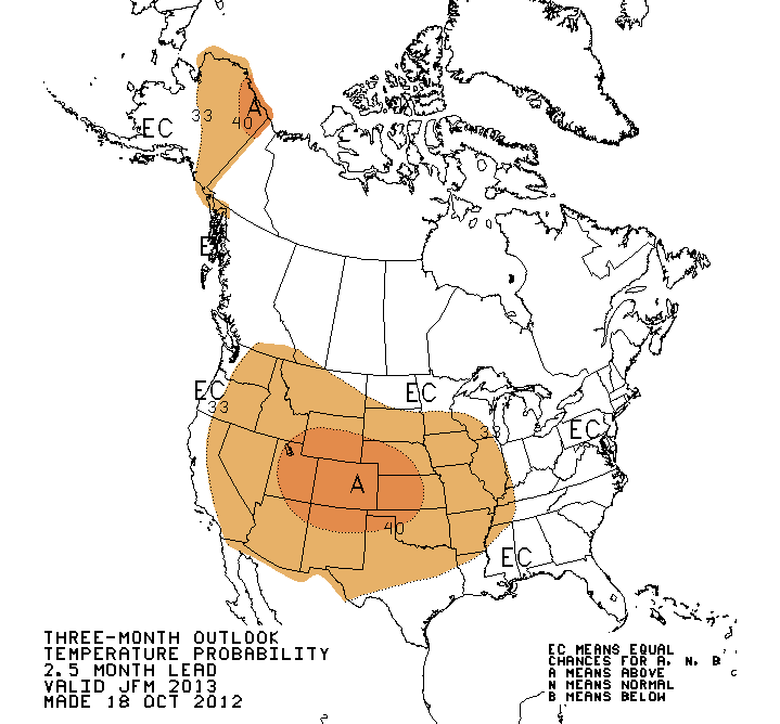


(TOP) Images show the Climate Outlook from NOAA showing you the 3-Month Outlook from January to March and showing you the VERY Warm Temperatures remaining in control in the Central Rockies, including WY.  West of the Mississippi River will remain Warm and as far North into Northern MT.
Precipitation wise, Equal Chances of Normal Snow/Rain, but could be a Dry Pacific NW and Wet SE Coast.

CURRENT WEATHER PATTERN:  For the past couple months, we have seen a copious amount of Pacific Coast Moisture and pushing to the East into Idaho/MT and into Western WY.  Tremendous amounts of Rainfall/Snowfall in Yellowstone/Wind Rivers/Tetons and then after it Crosses the Divide into the Basins....poof!  This also is an occurrence for the Bighorn Mountains, too.  Its gone, just clouds and wind and cooler air retreating down the mountain.  Then, Low Pressure 'tries' to form as it gathers energy and dynamics hundreds of miles from the mountain into the Midwest.  Rain chances go from "Likely" > "Slight".  WHY is that?  This is known as Orographic Rainfall.  Here is a Map showing you.


FINAL THOUGHTS FROM JOHN SHRABLE AND I

Both of us got together recently and shared/collaborated ideas of what we think 'could' and what will happen.  John thinks that the Jet Stream will remain quite North of us into MT and giving them a better chance of Precipitation and feels the Warm Air will stick around.

John and I Both agree on that we will see periods of Low Pressure spinning off the Pacific Coast and will interact some energy and give us Snow chances, but not as much as we have seen in years past...like Winter 2009/2010.  The Normal Area's that get more snow than other places will see the snow, but keep an eye on the Temperatures during our 7-Day Forecasts...Watch the Almanac and see where we are with the High/Low and compared to the Normal.  LATELY, we have been Warm about 5° Above Normal and slightly a little more than that.

SO WHAT DO WE THINK.....?
After our thoughts and agreement, we are going for a WEAK EL NINO.  I do think the Pacific waters will remain slightly warmer than average and continue this Warm Weather pattern, until a shot of Cold air comes down from Canada.  SNOWFALL, should be less than average here in Casper & Riverton, but still continue the Heavy Snows out in Western WY.  REMEMBER, We are Already 2" Below Normal to begin October in Casper and already in November, we are Below.

NORMAL NOVEMBER SNOWFALL:  -Casper: 12.0"   -Riverton:  5.0"  -Cheyenne: 8"


ONE LAST THOUGHT:

 You can attest me on this, but it is very challenging to forecast  here in this state.  John and I are pretty accurate with Temperatures and Precipitation for the 7-days and up to 10 with latest Weather Models we forecast with, including weather patterns and steering flow  from different levels of the Atmosphere.  

We May be Completely Wrong OR completely Right with these predictions. This is why its called Climate...climate Changes every second, but we will continue to FORECAST the best of our ability day in-day out.  

HAPPY WINTER!

Mike and John