Monday, January 27, 2014

1/27: Mid-Late Week MESS

Good Late Evening Folks,

BUNDLE UP if you haven't done so yet for the Overnight.  High Pressure builds as the Arctic Air mass invades for an Evening in the Plains and Rockies:

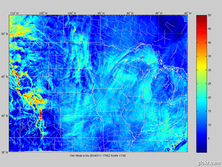
As for TUESDAY, I think we'll stay Dry & Cool, but the Southwest flow will increase through the Afternoon. Safe Travels along the Wind Prone Corridors along I-80 and I-25 as the Snow will be blowing.
 

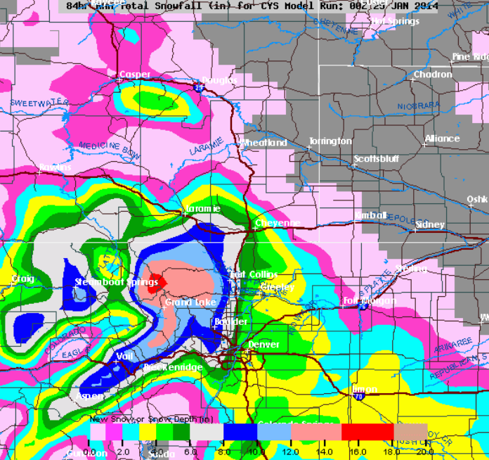
Mid-Week Confusion is the Best way to put it as we roll into WEDNESDAY.  Snow is likely for a good chunk of Western WY based on Evening Model Guidance.  This is our New Storm coming on-shore from the Pacific Northwest as lots of Moisture and Dynamics are in placed.  Over-Running Moisture will pour in with Several Inches of Snow and Feet in the Mountains and Western Valleys.  Central WY looks to stay Blustery/Dry through the Afternoon, but won't be surprised if we see a Mix bag of Precip when Evening rolls around past 5PM. 
(IMAGES BELOW)
Your animation


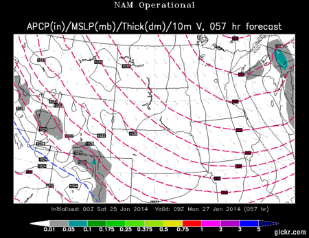
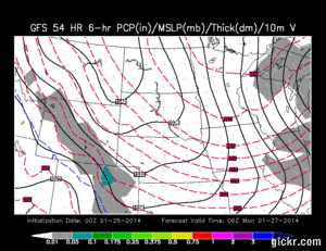
Evening Model Guidance shows a  MOIST Flow of Snow for Western WY on Wednesday, but it'll take a hard time for that Moisture to spill East of the Divide since the Wind Energy can tear apart the Storm.


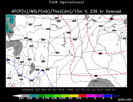
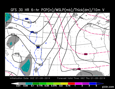
THURSDAY/FRIDAY:  Not really going in-depth with these two days, BUT something was very Interesting as I forecasted this Afternoon and Evening.  What you want as a Meteorologist are many "ingredients" that come Together (Lift, Moisture, Dynamics, Forcing & COLD Air)  Monday Morning Data suggested lots of Moisture, Upslope Lifting and Forcing of Air Masses with a Stalled Boundary in placed along the I-70/80 Corridors.  Moderate-Heavy Snow showed up in Central WY through Casper/Cheyenne and along I-80. 

HOWEVER, Evening Weather Data tonight showed all those Ingredients about 75-100 Miles than originally placed.  What does this Mean?  DRIER and Slight chance of Snow in Central/Southeast WY while Utah/Colorado gets the bulk of the Moisture along I-70.  This storm does show signs of ugliness as a tight Low of 996/992mb is Possible with Strong Upslope. Anything below 1000mb is something to grow concern.

THOUGHTS:  If you still want a big Snow, don't be "boy who cry wolf" yet.  Its still possible as Model Guidance can fluctuate back and forth.  I look at Four Weather Models (NAM/EURO/GFS/CANADIAN) each day and all the Models can show similarities or differences.  Each Storm is different and the Storm Track can alter or adjust its course the Night Before.  Why this field is a Forecast... WE DO NOT KNOW for a fact once the Storm has Arrived.  This Season, its been a surprised so far as Storms have Stalled and Strengthened ontop of Central WY. 


Friday, January 24, 2014

1/24: A little bit of Everything this WEEKEND

Well quite a Balmy & Breezy Saturday setting up Shop in Wyoming.  High Pressure keeps us dry and the "Chinook" Wind pattern off the Bighorns will keep Sheridan/Buffalo very Warm.  Plus warm weather will boost the 50°s in the Laramies.

SUNDAY is when the Weather starts to turn down hill as our Cold Front drops into WY with Falling Temperatures and Snow Chances likely.  Some Weak Upslope is possible in the Bighorns during the Afternoon so expect Higher Amounts in the Mountains

When MONDAY rolls around, we have our Stalled Front staying put along Central & Southeastern WY. Frontal Forcing and Weak Upslope could bring some Upslope for I-80 and Northern CO for the Afternoon. Here's what the NAM is showing (IMAGES BELOW)
Your animation 


 As for the GFS Model, its showing not as much Intensity with the Snow for MONDAY with their Guidance in Southeastern WY:
Your animation 

Here are the NAM & GFS Snowfall Forecast with the Sunday/Monday Storm. 
** THESE ARE NOT MY FORECASTS **
 
<<  GFS SNOW AMOUNTS


<<< NAM SNOW AMOUNTS


METEOGRAM:  The Bufkit does spit out some Lesser Amounts but I tend to "Agree" more with these before the Snow starts to fall.   
Casper ~ 1-1.5"
Lander/Laramie: 1-2.5"
Cheyenne: 1-4"

THOUGHTS:  We are still about 48 HRS or so away before the Snow starts but the Model Guidance is likely showing Snow developing on Sunday; but the Monday system is having trouble to verify the Amounts.  Though, I do think LIGHT SNOW is possible at this Time along the I-25 Corridor and expected Blowing Snow.    The COLD settles in on Monday as well, but that will be discussed on Sunday Night!  New Post later in the Weekend.

Friday, January 10, 2014

1/10: Wild West Saturday in WY; SNOW & WIND

Evening Folks,

For a "Complete/Detailed Forecast" Click HERE as I talk about the upcoming Weekend.

Lets get to the WIND Side of this Storm for Central & Southeast WY since it'll impact more People.'
 HIGH WIND WARNINGS are in the Light Brown shade that encompasses Eastern Park County and down towards NW Fremont Co (Dubois).   Everywhere along the I-25 Corridor from Cheyenne to Edgerton and along I-80 from Cheyenne to Laramie is affected. Shirley Basin and the stretch from Casper to Rawlins is under the WARNING.

However a WATCH is from Evanston to Rawlins


(BELOW) is our In-House RPM Model showing the Surface Wind Map from Saturday Afternoon to Early Evening. Through the day, the Wind Pressure Gradient will tighten up and Strengthen in Central WY as Wind Speeds "Sustained" will be about 30-45mph.  Expect GUSTS like you see in the Red along the Laramies or near Casper about 50-70mph  since the COLD FRONT is still way West in Idaho/Montana.  Temperatures will stay Balmy in the Mid-Upper 40°s in Central WY and nearing 50° around Cheyenne.

Your animation 


Now onto the SNOWY West.   Wave after Wave of Energy will pour into Mountains, but I think late Saturday Afternoon into Saturday Overnight will be the HEAVIEST of the Snow.
 
 * 1-2 FEET is expected out West and even into Southern WY for the Snowys and Sierra Madre's. I did put in about 2-5" for the Mtns East of the Divide, but that "may" decrease.  

* Not looking at a BIG Snow for Central WY, since this is not a favorable storm flow. 


Both Model Data this Evening from GFS/NAM are also showing HIGH Amounts out to the West about 1-2 FEET too!  This will be a heavy/wet/dense Snow out there.  So "WHEN will Western WY catch a break from the Snow and Dry Out?"  Looks like we'll stay Snowy through the Weekend and into Monday Mid-Day.   TOTAL SNOW AMOUNTS:  Since Snow began to fall on Tuesday and could last through Monday, some spots may see up to 3-4 FEET in the Mountains and 12-18" in the Valleys or even More..24"? 

That is why I titled it the Wild West Saturday. Either you'll feel the Wind or the SNOW

Tuesday, January 7, 2014

1/7: Unsettled Week for WY

Good Tuesday Evening Folks

Quite a CLOUDY Afternoon for all as Temperatures were cooler than Forecasted.  Otherwise, at leas the Winds were much calmer; except I-80 near Sweetwater County.

WEDNESDAY looks to be the same, but maybe a little bit more Sunshine is possible IF the morning clouds scour away. Breezy at times, but Temperatures should stay Seasonal.  Dry for much of Central WY and along the I-25 Corridor.  As for Western WY, we have more Shortwaves (pieces of energy from Low Pressure) that will bring Snow Chances once again with Light Amounts.

<< Western WY will stay in the 20°s but this "Moist" Zonal Flow (West to East Air Flow) favors this setup.


THURSDAY looks to be the Next "Cold Front" forecasted to push through Western/Central/Southeastern WY.  The NAM Model Guidance (below) shows Light to Moderate Snowfall for Western WY and once the Front slides in Central WY, the 'chance' of Light Snow is possible; only with small accumulation. A Trough will develop for Central WY so expect another Breezy Aftenoon in the Wind Prone Corridors.
Your animation 


And here is the GFS Model Guidance (IMAGES BELOW)
Your animation


FRIDAY Looks to be unsettled as it'll stay Breezy/Dry with Seasonal Temperatures, with more Snow Chances through the day for Western WY, but SATURDAY looks to be Active.  Balmy & Blustery with Mild Temperatures but SNOW increases once again out West later in the Evening.  I'll break down that Forecast in a couple days but Central WY could see a "snow chance" with this by Sunday Morning. 

Thursday, January 2, 2014

1/2: A CHANGE in the Weather Pattern looms near

HAPPY 2014!

This is the 1st Post of the New Year and Mother Nature didn't take any off day for sure.  For a Complete Forecast of Friday through the Weekend, click HERE

By the Way, my 2013 COUNTDOWN continues and I am talking about the #6 Event...yea, bundle up once you see this:


Okay...Here is something Cool I can show you.  This is an Animated way to show Graphics.  The newest GFS has come in and shows Big Snow developing Friday Night>Saturday Morning along I-80 as a 1012mb Low develops in Northern CO to provide some Upslope.  Moderate-Heavy Snow is possible from Rock Springs to Laramie. Something to Closely watch for sure is how the Morning Model Guidance picks this Up. This could threaten Cheyenne too, so it will be a close-call.

Here is what the NAM Evening Model Shows:  
Your animation 
<<Now, the NAM data doesn't show the Moisture as intense like the GFS, but here's what the Models pick out once the Cold Front passes.


NOW After our Wave of Snow on Saturday...another Shot of Light Snow is possible as a new Clipper ushers in by Sunday.  Not expect BIG Accumulations but the ARCTIC Plunge pours into the Dakotas/MN/WI area.  We will stay cold but NOT TOO Cold like last December
** Many will Drop in the Sub-Zero Category **
 

 THOUGHTS:  The Storm is still not set in Stone, but Light Snow is likely for Friday Night..early Saturday, "Maybe" Late Saturday, and possibly Sunday late Afternoon.  DON'T expect a big Accumulation but worry more about the Cold Air on Sunday/Monday Night