Saturday, November 30, 2013

11/30: Late Saturday Snow/COLD Talk

Its a Late-Evening Post but this Read can bring you up to Speed of what the Models showed Saturday for the Upcoming Storm.

<< LATEST Advisories for Wyoming.  Click on the Map to enlarge if needed.  But the Snow Potential for Western WY can vary from 8-20"in some spots.

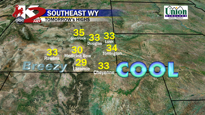
- BLUSTERY for Central WY in Casper and along the Laramies for Sunday Evening and through Monday in advance of our Front.


WESTERN Wyoming will get blasted with Snow with Moderate-Heavy Intensity through the Day on Sunday and into the Evening as a Trough passes by.  By Monday, the Snow Increases once again, as our Actual Cold Front Arrives from Montana/Idaho.  Central WY will stay Dry/Mild but the winds will be Howling!

-- GFS/NAM takes the Cold Front in Northwest WY by 5PM Monday Evening with Heavy Snow possible in the West as a very Deep 992mb Upper Low rolls into Eastern WY.  


** UPDATE **  Last Post, I mentioned how the Front could impact Wyoming by early-Mid Tuesday Morning, well....  IT has changed.  Since the Storm is gathering more Forward Momentum, the Front has now sped up on the Timing. Right Now, the Cold Front should impact Central WY during the Overnight Hours on Tuesday Morning.  Light Snow should break out and could be Moderate at Times in Casper area if the NAM Model verifies for Tuesday Morning (IMAGE BELOW)

<  Could be a tough travel to Work for Tuesday Morning so make sure you take some extra time as Roads should be slick with the Snow.

Blowing Snow is likely as the Wind Field gets Stronger.  Safe Travels Folks.


TUESDAY EVENING & WEDNESDAY looks to be Hazardous.  I think Snow is possible throughout Central & Eastern WY, but all 3 Models are showing different placement of "Who" will see the Heavier Snow and "When" the Snow will taper off. Right now, the Long-Range EUROPEAN Model has the Snow/Flurries ending by Wednesday Evening; however the GFS keeps Flurries through the Overnight for many of us and Light Snow in Cheyenne/Laramies.

** WHEN the Snow Tapers off, Skies should thin out and Dry out our Airmass. I do think we will go BELOW ZERO for Wednesday & Thursday Overnight. Daytime Highs should stay in the Low-Mid Teens for Central WY. Here is the GFS Forecast for Overnight Lows.

-- Remember, the Bigger our Snowfall Depth on the Ground, the COLDER the Temperatures could get IF the Skies Clear and Winds remain Calm.

-10° is Possible for Casper since we could see more Snowfall than other spots.  You see a lot of White in Western WY.  We could very likely see Temperatures about -30° or Higher!  

*DANGEROUS Temps, so take any precautions if necessary*

SO HOW MUCH SNOW?  I did Say that our Models increased of the Timing with the Cold Front about 12 Hours from Friday to Tonight's Post. That does have some effect to our Snow Potential too. A fast, quick hitting storm reduces a Moderate-Heavy Snow.

<< *THIS IS NOT MY FORECAST*  This is the GFS Snow Potential. Last Night, it showed Casper Over a Foot..now its 1/2 that.  And it pretty much Halved much of Central WY.

Cheyenne and the Laramies could still a Moderate Snowfall event.

- As I said last night, Please Take these Amounts with a grain of Salt as these Totals could change up or down by Sunday.  Snow is one of the hardest variables to Forecast cause its based on 
1)Timing
2)Intensity
3) Storm Track

THOUGHTS: After seeing the Data from the Morning to this Evening, its still that Coin-Flip or Luck of the Draw.  If Models slow down on Sunday, then expect a Moderate-Heavy Snow Potential for Central WY.  However...IF we see a Consistent Faster run like this with our Cold Front arriving Late Monday/Overnight Tuesday, expect a Light to maybe "Moderate" Snowfall of up to 6" in a few Spots in some Cities like South of Casper.  HEAVY SNOW for Western WY is a likely given from what I am seeing.

Friday, November 29, 2013

11/29: Friday Evening SNOWTalk

Evening Folks... a COPIOUS Amount of things to get too, so lets begin about this Weekend and I will break it down in Regions of the State since I cover a large chunk.

*Central & Eastern WY:  Mild & Dry Weather persists through the Weekend with Above Average Temperatures in Mid-Upper 40°s; but becoming Breezy through the Wind Corridors.

*Western WY:  A Broad Longwave Trough from the West will slide in on Saturday ushering some Light Snow throughout the Afternoon and Evening Hours. However, the Snow could likely linger on SUNDAY too as this is a very Moist Flow from the Pacific.

From Late Saturday and through overnight Sunday into Monday Morning, a few waves will usher in Light to Moderate Snowfall for the West ahead of our BIG Storm impacting the Rest of Wyoming by Early Tuesday.


MONDAY looks to be BLUSTERY for much of Central & Eastern WY along the Wind Corridors once again. Mild Temperatures as we will be Above Average for the High's.  Another Wave of Energy will slide into Western WY once again dropping another round of Several Inches of Snow. SNOW continues for Monday Evening for Western WY as the Cold Front blasts through the Region (IMAGE BELOW)


<< Tonight's NAM/GFS have been Similar for the Track and Timing AND the Intensity on the Snow for Western WY.


** Something to closely keep an eye out on through the Weekend **


TUESDAY MORNING looks to be the new Time-frame for Central WY as Evening Data "sped" things up on the Cold Front and the Precipitation.  I think it won't take long for our Mix>Snow Transition to develop.
What is very good I saw tonight was that the GFS/NAM Models Both agreed on the Cool Front draping over the  US 20-26 Corridor from Lander-Riverton-Casper

<< GFS & NAM do have Different Takes on a Low in Southern WY.  GFS likes a deep 1000mb Low developing in the Wasatch Mtns while the NAM is trending a Low right ontop of Casper with big snow North of the city and Douglas.


TUESDAY EVENING looks very Active as our Cold Front drops South into Cheyenne and along I-80.  Moderate Snowfall is possible for a while in Central WY as some Heavier Snow is possible near Rawlins and a good chunk of I-80. A compact 1000mb Low wants to now form in Eastern UT/Western CO so this could also mean Accumulation possible for the Laramies (IMAGE BELOW)


* HAZARDOUS Driving Conditions could be possible too, so please stay tuned for all the Closures. 


WEDNESDAY continues to be very Hazardous for a good chunk of Central & Southern WY; now including the Cheyenne area.  Moderate Snow (1"/Hour) could last through the Overnight and into the Morning Hours for much of the Cities. I don't think this will be a Bighorns or I-90 Snowstorm but Light Snow is likely.  I am concerned for Casper Mtn and Laramies area as this will be what "the Dr ordered" for Snowfall. By Late Morning, Moderate Snow continues and could be Heavy at times in a few Isolated spots.

<< UPSLOPE is Likely as a Compact 1000mb Low slides into West-Central CO and you can tell the Wrap-Around Moisture with the Wind Barbs showing a North-Northeast Wind shift.


WEDNESDAY EVENING looks Snowy for Southeastern WY if the Low stays compacted in Colorado.  Cheyenne could still Moderate Snowfall while Light Snow/Flurries are possible for Central WY (Lander>Casper) as the Storm system exits and the COLD Blast sets in as a deep Surface High plows in.


<< Denver 'could' see light to moderate snowfall if this pattern varifies.


THURSDAY could be BRUTAL if we see a Deep Snowpack, guys.  BELOW ZERO is likely and How Cold is still to be determined.  Lots of Dark Purple and some Red is possible on this Color Table.  
With the Snowpack, could see Temps dropping -10° very Likely and -30° in some Isolated Spots.  THIS is what i have been hinting at all Week, Folks.  It will be Cold, but this is Arctic Air. (IMAGE BELOW)


THOUGHTS: This will be a 1-2 Punch.  Moderate Snowfall 1st (6-12"), but then the Arctic Blast.  COLD/BITTER Temps are Possible by Thursday Morning and we 'could' stay that way for a while as not much of a Ridge could develop to "warm" us up anytime Soon.  I will keep everyone posted through the Weekend.  

AS ALWAYS, Storm tracks can shift ever so slightly, so the new Models could say something differently and the Amounts could either Drop or Increase. 


Thursday, November 28, 2013

11/28: POST-Turkey Day; Changes by Next Week

Happy LATE Thanksgiving to everyone and hoped you all were able to spend it with family or friends.  The "so-called" BLACK FRIDAY shopping starts now and personally not a fan of it one bit.  This is a holiday meant for being with Family/Friends but if you are Shopping on the Actual Friday, looking pretty good!

Not a whole lot to talk about except Mild/Dry Conditions as High Pressure Continues. Just some Upper Level Clouds rolling it, but that's it.


PARADE Night in Casper is looking Nice.  All systems are a "GO" for Dry and Tranquil conditions with a Slight Breeze.  Looking like we could slip in the Upper 30°s by 6PM, but depends on Cloud Cover. However, I hope to see you there as Yours Truly will be out there.  Dress Warmly and add layers to the Kiddo's..

SUNDAY looks a little Blustery for Central WY as a Longwave Trough slides in, but staying Dry. Above Average Conditions, keep in mind, for the Weekend & Most Likely on MONDAY too.  However, our Big Storm System is forecasted to slide in the Pacific Northwest and move into ID/MT with Snow likely for them.  Snow is also possible for Western WY.
<< MONDAY EVENING from the GFS Model shows Moderate Snowfall possible as and Upper Low moves into WY.  


TUESDAY  looks to be the very busy/active day as a Cold Front drops into all of of WY from the Morning to Evening Hours.  Lots of Cold Air and Moisture is with this System as its very dynamic. Right Now, the GFS has been fairly Consistent than the EURO Model so this is the reason why I am showing these Models.  
** MODERATE Snow is Possible for Several Hours in Central WY as a 1000mb Low could form in Eastern UT. Perfect Upslope placement for Western WY, Wind Rivers and Casper Mountains IFFFF this is Correct. **

-Another thing to see is the Amount of Cold Air diving South from MT into Wyoming by Tuesday evening too.  


WEDNESDAY still looks SNOWY and Cold once again. The Deep area of Low Pressure now moves East along I-70.  Moderate Snow is still possible in Central WY from the Overnight through all day.  Perfect Spot for Snow Lovers.Cheyenne could start seeing some Light Snow by the Afternoon Hours along the Laramies. Models are suggesting Light Snow>Flurries through Wednesday Evening as it should taper off for Central WY by Midnight or so.
(IMAGE BELOW)


THURSDAY for Central WY is looking COLD and Dry.  If the snow leaves fast and skies clear, most likely Lows will drop Below Zero. Arctic Air blasts through but maybe a few Flurries for Cheyenne area, but COLD is the word to know for the Afternoon and most likely another COLD overnight on Friday.


>> BRUTAL COLD Start and those Deep Purples are about -10° with our Snowpack on the Ground. Some spots show -20° in the Basins and also just West of Casper!  

IT WILL BE COLD, with out a doubt.  More Snow will increase those Colder Temperatures as Arctic Air invades WY once again.


 Here's the 7-Day for CASPER:


- For Now, I got -2 for Casper and -5 for Riverton, but that is "Conservative", since we don't know how much Snow is possible as of Yet.


Wednesday, November 27, 2013

11/27: CENTRAL WY Thanksgiving Forecast & a BIG Change Next Week

HAPPY THANKSGIVING TO ALL from Yours Truly.  Here is the Forecasted High's for Thursday.  Not expecting much except another Mild/Dry Afternoon with Above Average Temps and a Slight Breeze.

BLACK FRIDAY Shopping looks Nice for all of Central WY and pretty much its the same thing goes for the Rest of the Weekend; including the Casper X-Mas Parade at 6PM.  Planning on going, expect Temps to drop in the Mid-Upper 30°s at the Time, so put some layers on you and Kiddo's.

HERE are the 7-Days for Casper & Riverton... Nice 1st Half of Forecast, BUT Big change lurk as we roll into Monday.


EARLY NEXT WEEK...


(RIGHT)  An Arctic Plunge of COLD Air will dive down from Canada and slide along the Spine of the Rockies by Tuesday in WY and will bring a Cold Front dropping South fast.  Low Pressure is forecasted to form to our South in UT/CO and could develop some Upslope Potential for Central WY.  Both Long-Range Models (GFS/EURO) show Inconsistency, but what I can say is that "Accumulation" is Possible.  Later in the Week, we can get an idea what Models "suggest".

TEMPERATURES are suggesting once the Snow Passes to remain in the Teens for High's and Possible more Below-Zero Overnight Lows and it depends on the Amount of Snow, and Clearing Skies.  As Always..stay Warm and Weather Aware.

11/27: Southeastern WY Turkey Day Forecast

Quite a Balmy Afternoon East of the Laramies with Highs climbing in the Middle 50°s.  Maybe not as Warm like that on Thursday but we will continue the Above Average Temperatures under Dry/Sunny Conditions.


Rest of the Week and Weekend looks Above Average so Holiday Shopping plans should be tranquil and Nice.  However, a Change of the Weather Pattens shifts to a Cold/Snowy pattern maybe as early as Monday Evening.  I mentioned this last night, but will continue to trend an Accumulating Snow is possible.  Storm Track, Intensity, & Timing are still the variables we need to pinpoint but once the Weekend rolls around, a better handle of the Storm is possible.  SNOW does increase though for all of Southeastern WY early Next Week.

Tuesday, November 26, 2013

11/26: SOUTHEAST WY; Holiday Forecast

Sounds like a Broken Record, but if you enjoyed Tuesday...well ya probably going to enjoy Wednesday.

As for Tonight goes, not much to discuss as the winds could pick up slightly from the Southwest at 10-15mph.  Dry Conditions as many will drop in the 20°s and a Few Upper Teens.

WEDNESDAY:  Warmer, but a little breezy as we'll stay Dry and Sunny.  High Pressure will Dominate our Forecast as Ridging protects us from any Storm Chances.

<< ANY Travel plans heading toward Denver is looking A-OK!  BUT, if your planning back East along the Coast looks Dicey. Large Coastal Storm will likely cause numerous delays with Heavy Rain and Snow likely.  Pretty much, a Complete Mess.


LOOKING AHEAD:  Turkey Day is most likely a Repeat from last year.  Dry/Sunny and Mild for Thursday and maybe a Slight Breeze as many of the Laramies should stay in the mid-upper 40°s. 

ANY Black Friday Shopping or Weekend Holiday shopping looks Fine.  But a change in the Weather returns early Next Week.  Colder Air and a Low forming could likely increase our SNOW Chances from Monday PM-Wednesday in the Laramies.

Friday, November 22, 2013

11/22: SOUTHEAST WY Friday Evening Post

Whewww...it was definitely a Frosty Morning to start Friday.  Here are the Observation Sites showing the Overnight Lows across Wyoming:
Once again, another Clear Night, but the good thing is NOT AS COLD.  


Saturday stays Dry & a little Breezy at times, but Cool.

As we Look Ahead Early Next Week and for the Thanksgiving Holiday, not too 'Shabby!  Mild/Dry Conditions as we'll be under the Influence of a Ridge and weak Boundaries dropping South into Montana and the Dakota's.  Overall Dry!

Thursday, November 21, 2013

11/21: FRIGID EVENING and Looking Ahead for Central WY

Before I speak about our COLD Night, we had some Snow to deal with:

NOW, lets get to the FRIGID Overnight Lows forecasted for this Evening...brrrrr.  In fact, I won't be surprised if some will drop below these Readings:
..Now you may ask Why are we seeing these Cold Temperatures?  Well, its due to Light Winds, Clearing Skies & a deep dome of Arctic Air with High Pressure diving South.

<< The Surface Map shows a very Compact area of High Pressure dominating the High Plains in SD/Western NE.


AND Here are the Current Air Temperatures across the Country at 9PM. Underneath that High...brrrrrrr

FRIDAY looks to be much Warmer than Thursday, though the Winds should come up a little bit.  So watch for any Blowing Snow along your Travels in the Wind Corridors.  SUNSHINE & DRY Weather for rest of the Weekend.


REST OF NEXT WEEK & TURKEY DAY:   Not much to worry about from looking at the Long-Range Model Data. We'll be influenced by a weak Ridge from the Southwest but staying Dry and slightly above Seasonal for much of Central WY.  Thanksgiving looks Dry (so far) but only thing Im watching is a weak system that could dive down on Black Friday Night (Friday PM)...Keep you Updated.  HERE are the 7-Days for Riverton & Casper


WINTER OUTLOOK: via Climate Prediction Center

The CLIMATE PREDICTION CENTER has released their Winter Outlook for this Season. I did one last season, but I opted not to this Season. Why?  Well, why talk about Winter with snow since it can Snow any Month of the Year in Wyoming and the Main Snow could drop early in the Fall through the Late Spring.


For an In-Depth Outlook over the Precipiptation & Temperatures, click
HERE


11/21: SOUTHEAST Wyoming Evening Post

Well, not the best Snowfall for much of Southeast WY and the Laramies.  Frigid Temperatures prevailed with Highs only in the Teens.

COLD Night is in Store as High Pressure ushers in Central/Southeast WY.  It will be the Coldest Air we have seen so far this Season as Arctic Air invades the Laramies.


** BUNDLE Up, Bring Inside the Pets & May want to crank on the Thermostat for some of you all.


FRIDAY looks to be Warmer than Thursday, but still well-below Average with High's only in the Upper 20°s/Lower 30°s.  Windy possibly so some of the leftover could blow over the Interstates and Wind Prone Corridors.


LOOKING AHEAD: Just nothing much of Concern.  A new Low will form farther to the South by late Friday and the Weekend where the EURO Model showed a piece of the energy could slide along I-80, but the NAM/GFS stays Dry. So for Now, Im sticking with Dry/Mild Conditions through the Weekend and leading up towards Turkey Day!

Wednesday, November 20, 2013

11/20: SnowTalk Thursday

The COLD FRONT has arrived!  Blustery all across the Cowboy State as we'll drop in the Teens and a few spots in the Single Digits.  HERE is the Radar shot at 11:30PM Wednesday

Light & Blowing Snow will continue through the Overnight Hours for much of Wyoming, while some spots could see Moderate Snowfall in the Heavier Bandings.

From the NWS Riverton:  Heaviest Snow was developing over the Wind River Basin & Natrona County.  The BEST Snowfall should continue through Central WY & down towards Sweetwater County until 5AM Thursday

THURSDAY will be Cold, Windy at Times, and SNOWY.  Not expecting a Moderate to Heavy Snow, but most likely a Light Snow Event as this will be a quick hitting Storm.  

<< Snow should stay around through Noon for much of WY and as our Broad area of Low Pressure forms in UT/CO.  Some Upslope is still possible, but a big dome of HIGH Pressure will sweep in from the North Fast drying out our Moisture late-Afternoon.


THURSDAY NIGHT/OVERNIGHT:   Snow will taper off, and skies should clear out as well.  The wind should die down, but when the High Pressure sets in...COLD COLD COLD.  Likely see Single Digits and Below Zero Temperatures.  BUT, if you have More Snow, that will increase the colder Temperatures.  It will be so cold a 1044-1048mb Thickness Surface High will bottom out.  COLDEST Air of the Season.  May want to bring in your Pets for a couple Nights.

ALL of Central/Eastern, and Southeastern WY are under Winter Weather Advisories throughout Thursday Afternoon or early Evening. Being said, Here is how much I am going for out of this Storm as Evening Data stayed consistent with past Model Data from Wednesday Morning.

Tuesday, November 19, 2013

11/19: Tuesday Evening SNOWTalk

ALL Eyes point toward Late Wednesday & Thursday for the Snow-Hungry Wyomingites!  

I feel your pain folks, but lets get right to the Forecast.  The Front will begin to push from the North in Montana with Snow likely but as we arrive by the Afternoon Hours, we'll see the Front sag with some Flurries possible along I-90.  Central WY stays Dry but mild/Breezy ahead of the Front. 

<< Thought I think the Futurecast is slightly 'fast', BOTH Models tonight show the Front a smidge North.  


As we Roll into Mid-Evening, the Front will impact all of Central WY.  Winds will stay breezy and the drop of the Temperatures will be likely behind it.  Light Snow should break out for much of the Bighorn Country and maybe some Moderate Snowfall for Western WY as that Low will drop farther South into Southwestern WY/ID/ and Near Salt Lake. Flurries are possible for Central WY, but it'll take a while for our airmass to moisten up for the Snow to fall at the Surface since we will have low Humidity before the Snow Starts. 
 (IMAGE BELOW)
<< Though I do think Cheyenne will stay fairly quiet through the day, but I think they'll see the Front late Evening and early Overnight Hours.  

* The LOW Should be Broad, but not Compact at 1008mb.

Compact Low= Tighter Circulation and deepening Storm


SNOW should be light for all of Central WY as roll into Midnight and Overnight Hours.  The Low will sort of Stall or stay in one spot in Northern UT/ and Western WY.  Plus, the Front should drop into the Cheyenne area as High Pressure pushes it South. (IMAGE BELOW)


THURSDAY will be Cold & Snowy for much of Wyoming as this will be some of the Coldest Air we will see so far this season.  I think at times, the Snow could be Moderate (at Times) maybe near Casper or along the Laramies.  We have to watch and see as the Low tracks East along I-70 to our South in Utah/Colorado. 

<< What I am Forecasting is an area of High Pressure from the Dakotas/Montana drop South fast as it catches up with the Low in UT/CO along the Front. 

IF...Iffff, that occurs, some parts of Wyoming could see a nice band of snow developing for a Few Hours. But that is very Hard to Forecast. For Now, I am calling for LIGHT SNOW for most of the morning through mid-afternoon for a good chunk of Central & Southeastern WY.  Once we Roll into THURSDAY EVENING, snow should start tapering off from the North to the South as COLD AIR invades the Northern Rockies.  I think Flurries are likely for Central WY and Light Snow by Early Evening, but CLEARING after 9PM. (IMAGE BELOW)


MODEL SNOW AMOUNTS:  ** These are NOT my Forecasts **
 Here is the GFS Evening Run


...AND here is the NAM Evening Run: 


What I ALSO look at is a Forecast Snow Amount Range from the Iowa St Meteogram:

<< This is Casper: 2-5"

Other Cities show
Riverton: 1-3"
Lander: 2-6"
Cheyenne: 1-4"