The 1st Day of November wasn't a bad one. It was a little cool with the Wind but at least the Sun shined as all stayed Dry.
SATURDAY: Warmer and staying Breezy as we'll see the Winds shift to the Southwest. Staying Dry with Sunshine but our big storm system will usher in Snow in the Bitteroot's of ID/MT for Saturday Evening with Light to Moderate Accumulations.
SUNDAY: Much of Central WY will stay Dry for the Morning and Afternoon as our Cold Front will track West to East through the Afternoon. Light-Moderate Amounts are possible in the Western Mtn's but as the Front passes Central WY, we should stay Dry and maybe Light Snow possible in the Bighorns.


MONDAY: A Very Cold Afternoon once the Front passes and Drops South. We will stay mostly Dry in Central WY, but that Boundary really gets it act together late Evening in Colorado and SE Wyoming near Cheyenne. A Low is forecasted to form in Central/Southern CO provide Moderate Snow for the Denver area.
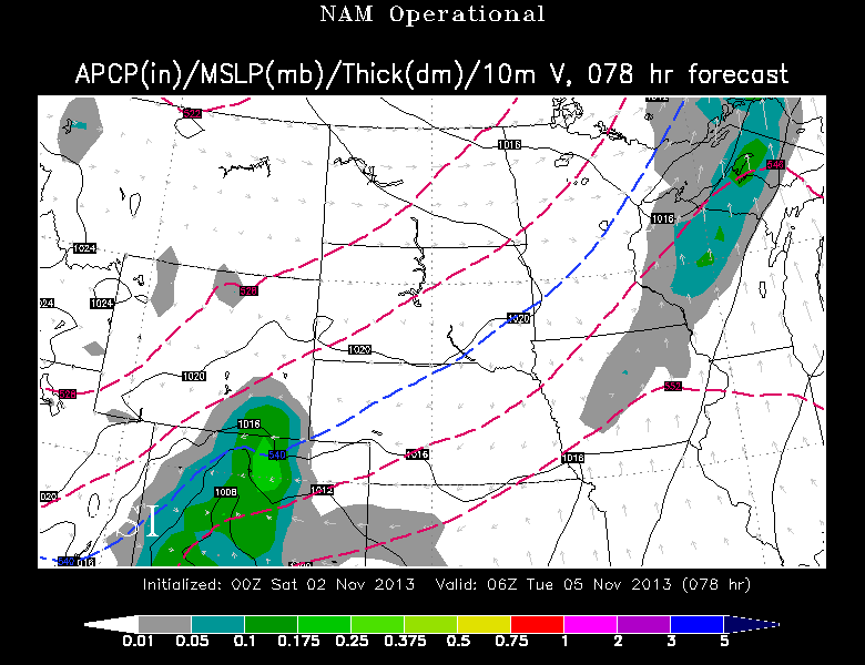
<< NEWEST Data from the NAM shows a nice area of Moderate Snow in the Southern Laramies as much of Central WY stays Dry and Cool. I-25 could be Hazardous for Travel.
This is what could happen by late Monday Night.
TUESDAY: Before we get involved of what 'could' happen, I think this is where the Models are really having trouble staying Consistent and Similar. Somewhere from Cheyenne to Denver along I-25, Travel will be Hazardous and Snow will breakout. MODERATE TO HEAVY Snow is possible where this Zone develops. Let me break down these two Models as they are showing Difference.

<< THIS is the GFS Model showing a compact 1004mb Low in Central CO by Noon Tuesday. Moderate to Heavy Snow wraps up in Cheyenne/Western NE. I-25, 80, 76 could be trouble for any Travel Plans.
Plus the Casper area could see Light-Moderate Snow if this falls into place.
* AND the newest NAM follows suit to this Run better than the EURO;

<< EURO Model from tonight showed a different stretch than GFS Run. Not as Heavy with the Snow in WY, but shows a Moderate band of Moisture in Central CO.
** Good thing is...it's still early in the Game of Forecasting.
SNOW AMOUNT POTENTIAL:
** This is NOT MY FORECAST** This shows the GFS Snow Amount that if this Model follows Suit, some impressive Snow Totals for the Southeast WY area North of Cheyenne. Take this with a Grain of Salt. How to read this? ...The Legend down below shows how much snow is possible for each color.

No comments:
Post a Comment