Monday, September 30, 2013

9/30: SNOW TALK for Late Week

Good Monday Evening Folks,

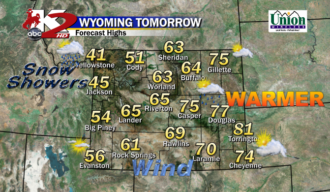
What a Blustery way to start the Work Week with SW Winds gusting easily between 40-60MPH.  Luckily Tuesday is looking better as a Weak Front will work through dropping the Temperatures just a tad, but the WINDS will stay calmer in the Afternoon. Not expecting any High Wind advisories at this time.


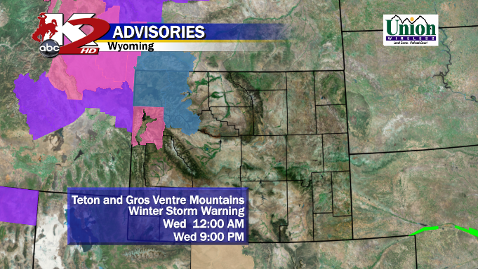
WEDNESDAY:  We will stay mainly dry through the the Afternoon with below average Temperatures in the low to mid 60°s as a weak wave of energy forms later in the evening.  Could see a 'slight' chance of Rain in Central WY and maybe a Rain/Snow Mix in the Higher Elevations of Absaroka's or Bighorns (IMAGE BELOW).  Just a ripple in the Jet Stream I like to call it.  Nothing too major, but this will slowly enhance our new storm to Form for Thursday.


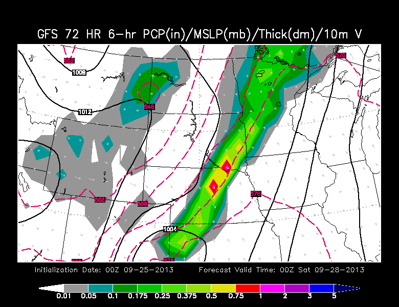
THURSDAY:  This is where the Models begin to get tough to forecast where all of them Split apart.  The newest NAM shows a deep layer of Moisture developing in the Bighorns and spreading along I-90. We will track a 2nd Front bringing colder air as the Snow/Mix will wrap around to All Snow just North of Casper.  What I am seeing is a weak Low developing in Southeast WY; which favors Northern WY and SD for Snow.  "Could" be a big snow for Rapid City & Black Hills if NAM wins out.  (IMAGE BELOW: Midnight Thursday)

- Central WY could see maybe a few flurries as some Dry Air could work in; limiting the Snow Potential also including Cheyenne by Midnight Thursday


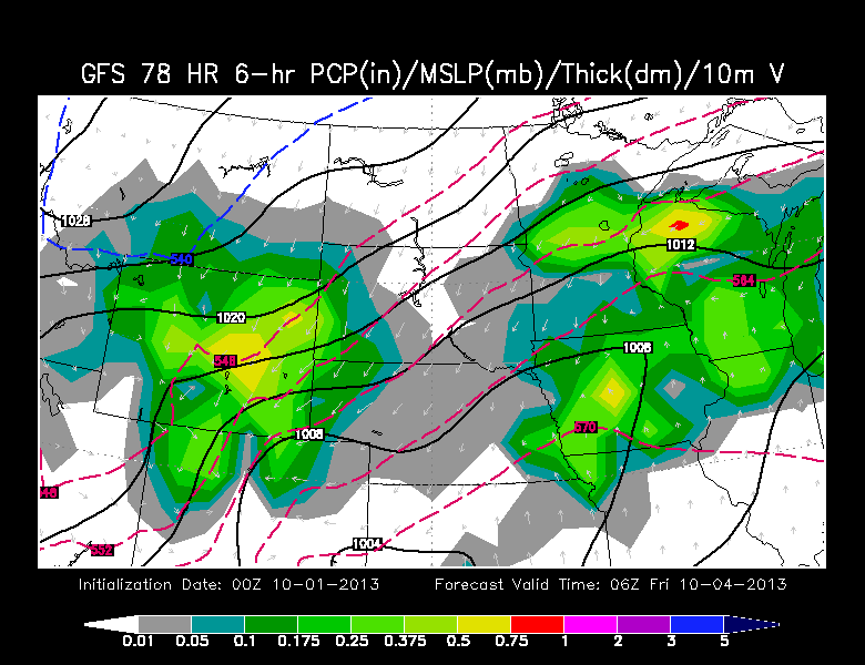
-- GFS is for the SNOW Lovers.  Moderate to Heavy Snow wants to develop by Thursday Evening in Central WY and stays there by Midnight.  The Earlier GFS showed this too and stayed consistent with this Run.

-- As you can see, a broad area of Low Pressure is forming in Eastern CO.  If you WANT Snow in WY, that's where you want it for Central & Southeast WY.  
-- I do see a clearing edge in Southwest WY, could be some dry air forming...keep that closely monitored. 


<< Even the Canadian Model is showing the Big Snows for Central & Southeastern WY with Moderate to Heavy Snow with an Intense/Broad area of Low Pressure in CO/KS/NE by Late Thursday.


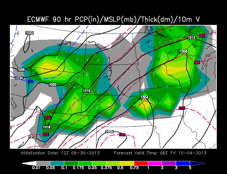
<< EUROPEAN by Late Thursday shows a little "Drier Air" working in Southwest WY and maybe around the Wind Rivers too.  However we do see Moderate Snow along the Bighorns/Absaroka's & along the Laramies, with ALL Rain for Cheyenne area.


FRIDAY AM:  So lets break down the Early Morning of Friday from ALL Four of these Models since they show different aspects.  However, I do feel the Models this evening sped up the Storm which could be a Quick-Hitter..Gonna walk you through each one:

<< NAM shows that HEAVY SNOW along I-90 from Gillette to Black Hills & Rapid City.  Travel looks treacherous for I-25 toward Casper with Light Snow developing in Central WY; AND still dry for Cheyenne.


<< GFS continues Moderate to Heavy Snow along and East of I-25 especially in the Laramies.  The Low is farther South as compared to the Midnight Timeframe. 

**Remember, GFS = BIG SNOW!!! **

-- At times, GFS is a little aggressive on their Moisture so this could be far-fetched too


<< CANADIAN Model at 6AM Friday shows the Low farther East with a deep compaction of the pressure at 1000mb.  Light to Moderate snows on I-25 with treacherous travel.

BIG SNOW's from them.


-- EUROPEAN Model is showing Light Snow for Central WY and Big Moisutre/Snow with the Bighorns & Laramies.  

I have a feeling some "dry-air" from that EURO model has to be carefully watched if it stays consistent.

-- Also, you see that Broad Low in Central NE/KS keeping the bulk of the Snow in a Band for Western NE/SD.


FRIDAY EVENING:  As we pass the Noon time frame and linger through the Day, the snow will still fly around, but how "much longer" and the Intensity?  Lets take a gander.


<< GFS shows that Low tightening up with a Severe Threat in the Midwest with Light Snow continuing along & East of I-25..with Heavy Snows in NE/SD.  

-- GFS does show the Snow exiting out of WY by late Evening and remaining cold for the Overnight.

 -- Want to Mention the Canadian & EURO Model shows the same Same from GFS as the Low moves East and Snow ending by Early Evening.


EARLY THOUGHTSHonestly, its still TOO EARLY trying to figure out where this Storm will form, the Speed, and HOW MUCH Snow your city will get.  Luckily we have 2 Full Days left (Tues/Wed) tracking this Sucker.

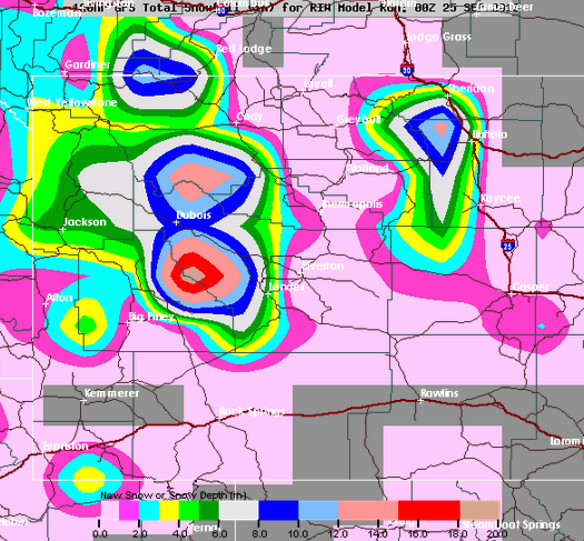
** Before I leave, I want to leave you a "Worse Case Scenario" slide of what the GFS is painting out.  Remember, the GFS can be overdone with Amounts.  Here's what its showing for your area. Plus this is NOT my Forecast.

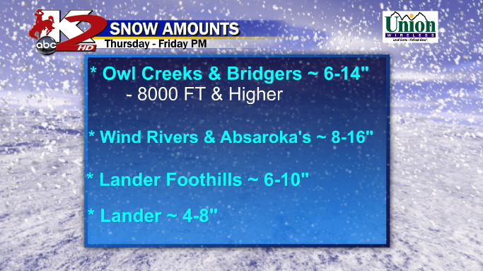
*Casper: 6-12"  Mountain: 12-18"
* Riverton: 1-3"
* Lander: 3-8"
* Laramie: 10-12"
* Cheyenne: 6-10"
* Douglas: 5-10"

Sunday, September 29, 2013

9/29: EARLY OCTOBER SNOW??

Good Late Sunday OR Early Monday Folks:

We should be talking about the Blustery, Breezy, Windy or "Hang on to your Hats" conditions for Monday & Tuesday.  Yea, it'll be Sunny & Seasonal in the 70°s, but not really an enjoyable way to start the work week.

As we approach on Wednesday, the Front from the North and West, will swing around and start cooling us off; like how LAST Weeks storm began.  I think the Higher Elevations in Northwest WY could see some light snow working in. Here is how the GFS is shows this Front sliding through.

--  NOW, this Storm System will be Cooler than last weeks storm cause you can see that Freezing Line (540) in the Northwest.

--This storm, as compared to last week, looks to dig South through the West..something that is not a good sign since it can set up a NEW Area of Low Pressure to form to our South.


However, the EURO from Earlier Today looked faster and showed signs of maybe a Rain/Snow/Mix in Central WY by late Wednesday?  

THURSDAY 6PM:  EURO Model shows "Lighter" intensity than the GFS but both show a Secondary Cold Front pushing into WY from the North dropping down.  Overall, it'll be a Cool Day for many maybe in Upper 40°s or Lower 50°s. 
 *Now, here is what the GFS is showing by 6PM Thursday (IMAGE BELOW)

-- A rapidly developing Low in NE Colorado (1000mb) forms providing Upslope Flow in the Mountain area.  Light to Moderate Snow in Western WY and Bighorns as much of Central WY could 1st start out as Rain to moisten the Airmass.


MIDNIGHT THURSDAY:  As the Low stays in the same spot, the storm INTENSIFIES.  The GFS is showing "All Snow" for much of Central WY with Moderate-Heavy Banding.  I think the Cheyenne/Southeast WY area could see all rain at 1st before they switch over. EURO at this time shows Moderate snow in Bighorns, and maybe a chance of Flurries in Central WY & Lgt Rain in Cheyenne.

-- GFS by Midnight Thursday is very intense as Heavy Banding could develop to near 'white-out' conditions if this Verifies.


FRIDAY 6AM: Before I show you the GFS, the European Model at this time shows very light snow through WY  and Minor Accumulations.  Now as we wake up in the Morning, the storm gets Heavy through the Overnight and continues in the Morning for Work.  Moderate to Heavy Snow all along the Laramies, from Casper to Cheyenne, along I-80 and even in the Black Hills.  Very Mature storm and a grimacing picture if you have any Travel Plans.


-- The GFS is showing the Low slowly moving slightly East now in NE/KS as that large swath of ALL SNOW reigns down in the Laramies.  Much Colder air with this storm as that Canadian Cool Front slides in from the North.
FRIDAY 6PM:  Light to Moderate(IMAGE BELOW) snow will continue (via GFS) as the Low pushes North and East into Omaha, NE by Evening but the back side shows Cold & Snow.  Such a Mature Storm with a tight Low compact that could bring more Severe Weather to our East in the Midwest.  GFS/EURO is showing this storm moving out of WY by late Evening on Friday and could be a Cold Night with a fresh layer of Snow.


EARLY THOUGHTS:  This could be a very big snow from Lander-Riverton-Casper-Cheyenne IF a Southern Low forms in CO off the East-Slopes of the Rockies.  Still there is plenty of Forecasting left to do from Now > Early Thursday to know the Track/AMOUNTS & the Consistency of Model Runs.

** Some Models show over 6" in Lower Elevations including Casper, Douglas, Lander, & Cheyenne

Thursday, September 26, 2013

9/26: The SNOW IS HERE

11:00 PM Thursday


GOOD Late Evening Folks,

The SNOW has arrived and talk about a lot of heavy/wet flakes for parts of Central WY in Riverton & Lander areas. 
LATEST: You can see that Large/Deep Low shooting moisture from CO/UT Northward into Central WY in the Wind Rivers, Casper area, & Bighorns.  We will continue this same trend as Light to Moderate Snowfall will stay with us through the Overnight.  However, a new Low will slowly form to our Southeast in Northeastern CO providing more upslope and maybe a chance of Casper to see a "light snow" chance.

We will continue the Winter Storm Warnings for Lander and the Wind River's E&W Slopes until Noon Friday. Elsewhere, we will keep the Winter Weather Advisories until Noon Friday for lesser amounts of Snowfall:


As we wake up in the Morning, Light to Moderate Snowfall should continue in the Wind Rivers, Basins, and up in the Mountains.  Casper can see some light snow to maybe a mixture. I think several places will see that chance of seeing some Mixed Precip along I-90 as well from Buffalo to Sundance.  However, maybe a few Rain Showers E of the Laramies, as they may see a Cold Rain


NOON FRIDAY:  Snow should come to an end and Transition to a Rain/Mix for many spots as Temps should rise in the Mid to Upper 30°s to Lower 40°s.  A lot of the activity should decrease but the Moisture will shift farther East in the Black Hills


FRIDAY 6PM:  We could see some residual moisture as the Front moves out of Central WY and the Temperatures could be just slightly above Freezing with a Rain/Mix near Cheyenne for the Commute home.  Cold/Dry for the rest of the Evening AND Saturday looks fine. Sunny & Dry, a touch Cool in the 50°s


HOW MUCH SNOW COULD WE ALL SEE?

<< Some could see banding of this Precip so expect higher amounts if Bands do form.  

* Not so much of a Storm for Casper as we stayed Warmer on Thursday as Temps had trouble to drop fast. 


<< The Mountains will gobble up a lot of this Snow.  And this goes the same for the Mountains...if any banding occurs, expect isol'd higher amounts..maybe a Foot and a Half???

Wednesday, September 25, 2013

9/25: AM THURSDAY ~ SNOW Storm Update

What a Wednesday to recap as that powerful Cold Front slammed through much of WY with blustery winds and a fast drop of Temperatures, while parts of Western WY ranged from 2-6" and even a report of 11" at Togwotee Pass Snotel.

THURSDAY AM to 6PM:  As we wake up,  much of WY will stay Dry and could see some peeks of Sun at times.  This is the Critical time frame of whether what kind of Precip many of us could see as we near Overnight Thursday of when that "Transition" begins. Here are the Temps I am going for:

< You see a Temperature Difference drastically from Casper to Riverton, since I think it'll take a longer time for the Basins to warm up.  We'll stay dry until our "2nd Punch" arrives as a new Cool Front will usher in another drop of Temperatures. 


THURSDAY PM to MIDNIGHT: NOW, this is when Conditions will deteriorate as our Cool Air will sink in as that New Low will form from our South in CO bringing that Upslope effect of Moisture.  However, the Newer Weather Data from Wednesday Evening is still Different in Temperatures but getting that better consistency of the Precip placement.  I'll show you what I am seeing:

GFS @ MIDNIGHT THURSDAY

<< GFS this Evening shows ALL Rain for Casper when Midnight rolls around as our Low intensifies in Eastern CO.
- Riverton/Lander at this time will be a little cooler than Casper, but I think they'll stay mainly rain and maybe some Frozen Precip may mix in at times.
- Bighorns/Owl Creeks/Wind Rivers could see some Mix Precip to Snow with heavy Intensity as our Low explodes to the Southeast.  
- NOT SHOWN, but the EURO Model was consistent with the GFS on the Temps & Precip placement.


NAM @ MIDNIGHT THURSDAY

<< NAM this Evening was actually cooler than the morning run from Today.  

-Plus, the NAM is different in Temperatures than the GFS...Why?  They are about a few degrees COLDER.  This means that the Precip could Transition from Rain to a Rain/Mix faster...plus sooner time to see the Snow chances to pile up.

-- ALL the Mountain Ranges should start seeing Moderate to Heavy Snow at times.


<< Our In-House RPM run is showing that Change-Over from RAIN to SNOW around the Overnight Hours around 1-3AM Early Friday Morning for much of Casper, Riverton, & Lander; while it'll transition earlier for the Mountains.


With all the Snow Potential for the Mountains, we are still continuing the WINTER STORM WATCH for many of the Mountains; also the Foothills of Lander from Thursday Evening to Noon Friday.


For the Areas that are Experiencing the Winter Storm Watches, Here are the Amounts I am going for at this Time.  This could be subject to change based on the Intensity of the Storm and the arrival of the Transition from the Rain>Mix> all Snow.
 FRIDAY AM to NOON:  Continuing with the GFS & NAM Model Runs, they show the Similar Placement of the Precip, BUT still lack the same Temperatures.  NAM is much Colder, while GFS "slowly" decrease the Temperature drop.  Here's what I am seeing:


 <<  NAM by 6AM Friday shows a cold ( 546 Thickness) along and West of Casper.  IF this verifies, we have SNOW for Casper and all of Fremont Co too.  Snow will be Light, but maybe Moderate at times if any banding develops.


 << GFS by 6AM Friday shows a "slightly" warmer ( 552 Thickness) on top of Casper..and cooler to the West in Riverton/Lander.  

-- Casper:  IF this verifies, we'll see a Snow/Mix through the Morning and Casper Mtn probably will get that Snow Chance

--Riverton/Lander:  IF this verifies, a slow transition to ALL Light Snow and Heavy Snow continues in the Mountains..while Cheyenne could see cold Rain.


<< Even the RPM is showing ALL SNOW for much of the Lower Elevations in Central WY with Light Snow..and Moderate Snows for the Mountains.


FRIDAY NOON to EVENING:  NAM & GFS continue to differentiate in Temperatures and Precipitation.  NAM likes Light Snow for all of Central WY through Noon and dissipates by Early Evening. GFS is still showing that Mix for Casper and Light Snow/Mix for Riverton/Lander through the Evening. 


SNOW POTENTIAL MAPS:

** Since this will be a very Heavy/Wet/Snow, I am using a 10:1 Ratio  1" Rain = 10" Snow & may have to factor in the Rain from Night before..so may have to drop an Inch or Two

** NAM SNOW AMOUNT**

-- IF the Storm Trends the "Cooler" NAM, SNOW galore for much of Central WY. 

Casper:  3-8"
Riverton: 2-5"
Lander: 5-12" 12 being near the Foothills of the Wind River's. 


 (SHOWN ABOVE)  Here is the GFS...Remember, the "Warmer" of the Two Models:

Casper:  1-3"  Casper Mountain 2-4"
Riverton: 1-4"
Lander: 3-8"


ONE LAST THING:... The Meteogram I use to Forecast Amounts...this takes a Range from various Models
Casper: 1- 4.5"
Riverton: 1 - 5.5"
Landeer: 4-8"


Tuesday, September 24, 2013

9/24: TUESDAY PM Snow Update

Good  "Early" Wednesday Morning Folks,

Quite a warm Tuesday  for much of Central & Eastern WY as they experienced winds increased through the afternoon propelling the Temperatures in the Mid to Upper 70°s.

WEDNESDAY:  A Cool Front from the North & West will slide in as it progresses Eastward through the Afternoon, so the Temperatures could reflect on the timing as the Front passes.  Shower chances & breezy weather continues for much of Central WY, Dry/Warm E of the Laramies, AND SNOW Showers (some Light to Moderate) in Intensity or a Mix could continue for Western WY. 

I mentioned how there could be a 1-2 Punch, well this 1st Rd of Cool Air will arrive by Noon for parts of Central WY
** As for Western WY, the Winter Storm Warning will go in effect from Midnight through 9PM Wednesday for the Teton's and Gros Ventre Mountains. And a Winter Storm Watch for YNP & Absaroka's. **
RIGHT NOW, I am going with these Amounts in Western WY.  However I won't be surprised if a few reports can tally up near a Foot of Snow:
THURSDAY:  As I mentioned last night in the post & this evening on-air, a "Re-Enforcement" of Colder Air is forecasted to slide in from the North as it Interacts with a NEWER area of Low Pressure from the South over the Rockies.  I still think we can see a "Lull" in the Activity for the 1st Half of the day before our 2nd Punch arrives; dropping the Temperatures once again.  THEN, the Fun Stuff begins as that New Low Develops around 6PM and intensifies by Midnight.  Here's Why:
0z GFS valid for 12AM Friday

<< GFS by Late Thursday has a Strong Low in NE Colorado (1000mb) with Moderate to Heavy Precip developing in Central WY as our Front pushes South.  NOW, if this System trends with this one, Casper could see more of a Rain chance while Riverton/Lander could see that changeover to a Mix.

I think the Mountains could see a mix of that Snow in the Bighorns and ALL Snow for Bighorns and Western WY, again.


<< NAM by Late Thursday is a touch Different than the GFS. 

Here's Why: 
1)  The Low is a smidge East and Not as Intense with the Low...only at 1004mb. Remember, the Deeper the Pressure, more Intense the Storm is.
2) NAM is Colder than the GFS for Central WY & this Evening's Run is colder than the Morning Run. Maybe this is a sign of what is to come? 
3)  NOT as much Precip for Casper area, but enough for the Wind River Basin/Mountains.  So we could see that change over fast from Rain>Mix>Lgt Snow?  HEAVY Snow is Possible for the Mtns.

FRIDAY AM:   From Midnight through the AM, we'll slowly watch the Colder Air usher in through Central WY and watch a Band of Heavy Rain/Mix/Snow develop in this Area.  Again, the NAM is Much Colder than the GFS and I won't be surprised if we see SNOW developing by Rush Hour for the Morning Commute. 


I think this is when that "ALL SNOW" alert can come into Play if the Storm works in with the NAM.  Light Amounts indeed for the Lower Elevations of Central WY with Higher Amounts in the Mountains.

-- Not showing it, but the GFS is still a tad 'warmer' than this NAM Run at 6AM Friday. 


FRIDAY PM:  Models don't vary once again on the Exiting of the Storm System. By 6PM, the NAM pushes the storm South & East of Central WY as Cheyenne gets it while a New Low forms giving them that chance of Rain/Snow/Mix.  HOWEVER, here is what the GFS thinks (IMAGE BELOW)

By 6PM Friday, some residual moisture lingers in WY to give us that chance of some Mixed Precip, while Cheyennes stays drier than forecasted.


SATURDAY:  The Storm travels East toward the Dakota's and Plains leaving us Cool but Dry as the Sun should come out and melt any snow thats on the ground as Temperatures will climb only in the 50°s

SNOW AMOUNTS from Different Weather Sites:

* When I forecast Snow Amounts, I "accumulate" lots of data from various sites that spits out different observations.
PENN ST E-WALL NAM HI RES SNOW POTENTIAL THROUGH 60 HOURS

-- HERE is the NAM Hi-Res Model showing you the Heavier Snows in Western WY and the Mountains showing about 6"+ in Bighorns & nearly a Foot or Higher elsewhere.

- Casper Mtn:  4-6"
- Lower Elevations: Anywhere from a   Trace- 3"


<< HERE is the GFS Snow Amount.  I included the Roads to help you out. 
** Remember, the GFS, was a little "Warmer" than the NAM for the Casper area, so thats why there is lesser amounts of snow for them and in the Riverton area.  BIG Snows for the Mountains where over a Foot is expected.


THOUGHTS:  With the Models still not consistent from one Run after another OR not agreeing with each other, its still a Toss-Up of what is expected. I think as we near the 'under' 36 Hour mark of the Snow Event for Central WY, Thursday will be a better day of having a Better Knowledge of what the Heck is going on.

BIG Storm for some in Late September.


-MS

Monday, September 23, 2013

9/23: Monday PM Storm Outlook for Mid-Week

Good Monday Evening OR Early Tuesday Folks,

After  our Cloudy start to Monday, we improved the Temperatures in the Lower 70°s for Central WY as the Sun came out.

TUESDAY:  Still expect a Nice Afternoon as we'll climb in the Low to Mid 70°s under Breezy, Dry Sunny Conditions.  As Evening Progresses, chances of rain Increase as the early effects of the storm will impact NW Wyoming.


WEDNESDAY:  Overall, it'll be another Seasonal, Dry, but Breezy Afternoon for most of Central & Eastern WY as our Cool Front will arrive.  A rapidly developing area of Low Pressure will begin to form in Eastern WY (996/992mb) as it'll provide a Rain Chance for Central WY.  However,  the Intensity of the Precip varies from all Three Weather Models. PLUS,  Wherever that Rain/Snow Line is hard to determine for Western WY.  

Thoughts:  I think the Higher Elevations could see periods of Moderate Snow as a Rain/Snow Mix could be sporadic as the Cooler Air ushers in from the West through the Afternoon and Early Evening

(0z NAM valid for Wednesday @ 6PM)

** With this Strong Low, some parts of Central WY could see a few Storms ahead of this Front. 

LATE NIGHT:  Here is where it gets Tough... the NAM Model wants to keep WY dry while the EURO & GFS Model shows a little more Moisture to see a Mix in the Bighorns..but Rain for rest of Central WY.


THURSDAY:  THIS will be a Critical Day of what could occur.  What is Forecasted to Occur is a Back Door Cold Front (Secondary Front) sliding in from the North dropping South.  How COOL our Actual Temps are will reflect on how fast they could drop later in the Evening to differentiate What Precipitation "Who" could see "What".


(0zGFS valid for Thursday @ 6PM)

-- GFS (shown here) & the EURO Model are Showing Two areas of Low Pressure forming to the South in CO & UT as light Rain could develop 1st in Central WY & Snow transitioning for Western WY.


LATE Thursday:  The newest GFS that came out showed a Heavy Swath of Precip on-top of Central WY.  Expect that changeover to occur to a Mix and the Higher Elevations East of the Divide (Wind Rivers, & Casper Mtn) could see some Snow developing.

FRIDAY:

AM:  As we wake up, all Models are showing the Upslope Effect take shape as a Low will deepen in NE Colorado/Nebraska area.  The NAM shows the storm with some "lighter snow" trying to fall. HOWEVER, its a different ball game from the EURO/GFS Models.
I think Temperatures will play a large factor of who will see what as we'll be Very Close to the Freezing Line.  Our Precipitation could "Band" and if that does, expect some Intense Snow/Mix/or Rain.  Casper Mtn could see some intense Snow IF this Occurs.

(0zGFS valid for Friday @ 6AM)

HEAVY Precip along I-25 as you can see and Moderate Snow is possible for Western WY. But Look, Still DRY for Cheyenne & the Laramies.  Our Spinning Low is near Greeley, CO wrapping up and sitting on-top.  A Weak Low in UT/CO could spark off more moisture for SW Wyoming.


PM:  This Low could stall out and keep much of Central WY unsettled through the Day with a Rain/Snow Mix all day with Cool Temperatures and light Snow likely in the Mountains. SOUTHEAST WY, I think when we approach Friday Afternoon > Overnight, this is where our greatest chance of seeing some type of Rain/Snow/Mix to all Light Snow event could occur.

SATURDAY:
ALL of WY should Dry out but the Temperatures will stay below Average maybe in the 60°s for High's.


NOW...  This is the Section where Many just want to Fumble Through and know..

SNOW AMOUNT POTENTIAL:

** PLEASE Remember that some of the Amounts could be overdone, that some could mix in with Rain **

- HERE is the NAM Model Amount that is valid through Friday @ 6AM:

-- A little less but you can see how much it is for your Area with the Legend showing you the Color Range in Inches.


- HERE is the GFS  from Earlier Today through Saturday Morning:


- One More SNOW Map..This is our In-House RPM Model that is valid until 6PM THURSDAY:

--Already, some parts are capable of seeing over 10" in the Higher Mountains...and this does NOT include the Thursday Night and so-forth Snowfall.


THOUGHTS:  It's Still Too Early in the Ballgame to fine-tune this, so it will likely Change but the Potential Exists for Accumulation in Central WY and Higher Amounts in the Mountains.