Monday, October 28, 2013

10/28: Monday SnowTalk and Looking "Ahead"

Good Cold & Windy Evening

Our Storm is on track to continue stay in Eastern UT providing better Snow Amounts for Western WY this Evening.  PLUS, some Moisture could linger on the Eastern side of the state for a Freezing Drizzle possible.

<< ALL Winter Weather Advisories (Purple) will expire at 9AM Tuesday

<< Freezing Rain Advisory for the Laramies will expire at 9AM as well.


RIVERTON & LANDER has won the Snow Amounts so far with this System as much of the Snow fell this Morning as the Front pushed through. Here are the Totals as of 10PM:

AS We wake up Tuesday Morning, Expect an Additional Amount of Snow in the Mountains as a new band is redeveloping.

* We Will see how much is Possible through Tuesday as periods of Rain & Snow will continue for much of WY.

TUESDAY PM: A Streaking band of Moisture will develop in Cheyenne area which could lead to a round of Light Snow or a Mix as the System travels North and East leaving many Cool & Dry


NEXT STORM...?

As we leave this System behind, remaining Cool & Dry as I mentioned also for Halloween but slightly warmer for late Week.  
Now for Late Week, a Cool Front will sag into WY once again and a ripple effect  in the Rockies could provide some Snow?

<< GFS & EURO both show this by late Sunday or Monday but are both off on the Timing by 12 Hours.  

Tonight's GFS Run didn't show this Feature but we will watch this if it keeps popping up from Now through the Week.

** Do Not Take this Storm with a Grain of Salt**

Sunday, October 27, 2013

10/27: Early Week SNOW/Mix Talk

Well Folks,

Its time to say Farewell to the Beautiful Week of Weather much of WY experienced with Above Avg Temps and Dry Conditions as conditions deteriorate.

SYNOPSIS:
As we work into Monday our Low from the North in MT will continue to produce widespread Snow up there and sag South,  but will become misplaced and have trouble finding its identity.  ALL Week, I said the Models have had a hard time knowing what it wants to do?  Well... the same follow suit as 'Scattered' Snow Showers/Mix will spread into much of WY through Monday evening. The Cold Front will drop our Temperatures in the 30°s but RIGHT NOW, I am highly likely the Heaviest Snow should stay in the Wind Rivers, Bighorns, and Western WY Mountain Ranges.
  CASPER wise, not so much on the Mountain since our Low will track from our West into ID/UT so its not a better Upslope Snow Event though light Snow is possible.  

**LOWER ELEVATIONS**:  I think for Casper/Riverton, we should mostly see a Cold Rain/ Sleet Mix/ and maybe a brief period of Light Snow with little to no accumulation expected.  However, FOOTHILL CITIES (Buffalo/Sheridan/Lander) could see a better chance of Light to Moderate Snowfall Amounts since the Low will swing around the Mountains to provide Upslope Flow; North-Northeast Wind Flow Component.

** TIMING**:  Snow should start arriving by Monday Morning in the Mountains and could be Moderate at times where much of Central WY & Lower Elevations should stay Dry. MANY Models have had a hard time debating when the Precip will arrive in Central WY as the best time could start either late Afternoon or Evening with a mix possible if the Cold Air wraps around.  KEY Point are the Temperatures.  Anything above 40 is highly likely Cold Rain.  Below Freezing could be Snow, but a Mix is possible with Temps at or slightly above Freezing since we have seen a lot of Warm Temps past week.  The LOW will linger through the Overnight and a mix bag of Precip will linger through Tuesday.  Some Slick Roads are Possible so safe Travels IF some will see Freezing Rain Drizzle.   I think some light snow is still possible as some cooler air is possible to arrive Tuesday Evening.   RIGHT NOW, the Models show the Storm moving East by Wednesday and could push into the Plains.  We'll closely watch the timing as Monday's Models could provide better Forecasting Confidence.

NOT MY AMOUNTS, but here are what some Models are thinking with this Storm:

<< HERE is the Weather Prediction Center's "Winter Forecast Guidance" showing the Wind River's, Bighorns seeing over a Half-Foot easily and possibly the Uinta's too.  

To Read this Map the Legend is on the Far Left  with each color showing the different amounts in Inches  


<< NAM Snow Amount Shows the Heaviest Snows in the Wind Rivers.

Here, Lander could see up to 6-10" of Snow but not so much in the Bighorn Foothills of Buffalo and Sheridan.  

South of Evanston in the Uinta's, could be a nice Snow for them to help out their Snowpack.
 LATEST ADVISORIES For the Snow now issued for the Wind Rivers, Sheridan Foothills, Bighorns and the city of Dubois:

Friday, October 25, 2013

10/25: Friday PM SnowTalk Update

SATURDAY/SUNDAY:  Above Average Temperatures will last through the Weekend as we'll stay Dry and Mild.


MONDAY:  The Cool Front digs South late Sunday Evening sending down the Cooler air, but the Storm will pulse in Intensity as it approaches WY and the Bighorns.  By Mid-Day, all Models show a Low developing in far Western WY/ID/UT as Upslope is likely in the Mountains.

** Both GFS/EURO is a little light on snow, but Flurries should start flying around by Early-Mid Afternoon for much of WY as the Activity will pick up with Light Snow through the Evening.

MONDAY PM: As we roll around the Evening Hours toward Midnight, the NAM slides farther East along the I-90 with Heavier Precip towards the Black Hills and moves out of Central WY.  EURO/GFS shows lighter Snow as the Low continues to weaken in the Southwest of UT/CO/ID.  Pretty much, the latest model scans show the Storm weakening in intensity with only light snow or flurries for much of Central WY.


TUESDAY: By morning the NAM shows NO SNOW for WY as it races East in the Plains.  Some Flurries linger through Noon via GFS/EURO, but its nothing worthy of talking about since the Storm tries to redevelop as a Cut Off Low in CA/NV.

NAM SNOWFALL AMOUNTS:

CASPER: T-1"
RIVERTON: 3-4"
Lander: 8-12"
Thermop: 6-8"


**Here's how you read these Maps, Folks:  The legend is down below and its shows the Color scale of how much snow is possible in your area.


GFS SNOWFALL AMOUNTS:  ** This was the Friday Morning Table, so the Evening run will most likely be Different. **


- I will post through the Weekend on the Snow Maps on the Trends of what the Models Say and How much is possible in your Area.


Thursday, October 24, 2013

10/24: Warmth before the SNOW

Going to be a small Indian Summer like few days for much of Central WY with above average Temperatures, Dry Conditions and lots of Sunshine.  Here is how warm some could get on Friday.


Fortunately, we will keep those Mild Temperatures through the rest of the Weekend here in Casper and for much of Central WY:


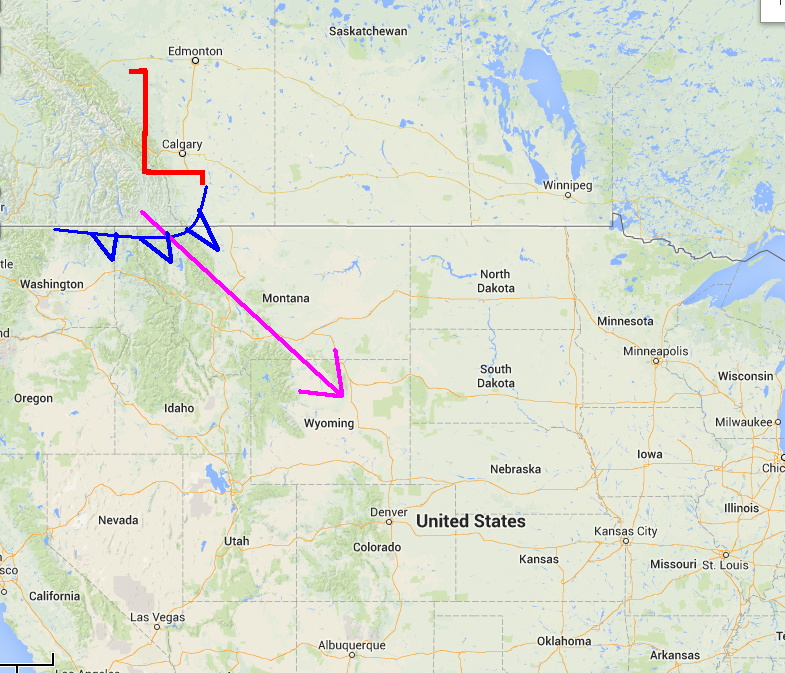
I did say SNOW, right?  Yep I sure did.  Sunday will stay Dry & Mild for all of WY for the Afternoon and maybe a little touch breezy, but conditions will deteriorate late in the Evening as our Cool Front swings down.
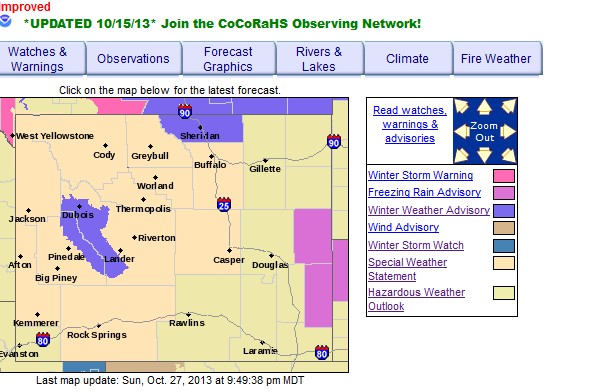
MONDAY:  The Cool Air is surging southward from MT into WY as snow will break out all evening Sunday to the North but Light Snow will increase Monday morning as Temperatures will drop from the 40°s into the 30°s.  Light to Moderate Snow is possible for Northern and Western WY, but Central WY should stay mostly dry until early-mid Afternoon as the 1st Flakes could drop.


<< You can see the bulk of the snow by Monday will stay in the Mountains as a 1004mb Low in UT/CO/ Southwest WY providing some Upslope.

* Dry for the Laramies by Monday Evening via GFS Run, but maybe some light rain for the area from what EURO Model showed earlier today.


<< As we head into Monday Evening, Snow could be heavy in the Wind Rivers and Owl Creeks as the Low gets a little more tight and organize in UT as a 1004mb Low.   Light to Moderate Snow at Times Snow is possible for Central WY but we will see how consistent these models stay.

*EURO model by late Monday showed two separate area of Moderate Snowfall as Light Snow is placed in Central WY and Cheyenne area.


TUESDAY:  The Storm is not in a favorable track for Moisture, 1st and Foremost.  When Tuesday rolls around, the Snow is still there and falling "Lightly" for much of the Lower Elevations as Moderate Snow is possible for the Mountains. 

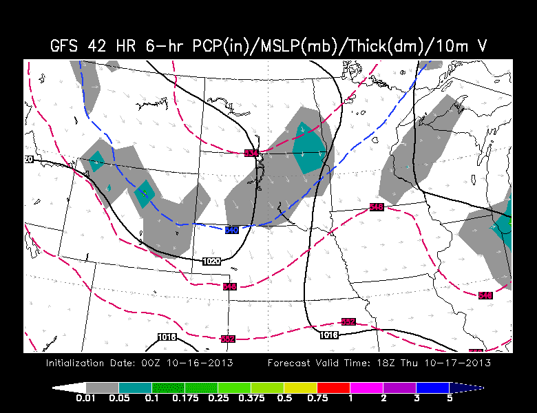
<< GFS still shows that Snow, but what its doing is that the Broad Low in UT/CO is not intense or deep enough to recharge the Atmosphere so it stretches or suppresses that Snow Band. 

* GET THIS, the Euro model by Tuesday Mid-Day has NOTHING for Central WY as flurries are scattered in Southwest WY.


NOT a whole lot to discuss when Wednesday rolls around as all the Moisture or Snow should dissipate by Tuesday Evening as we should stay Dry & Cool

SNOW AMOUNTS:  Predicting a Storm like this as it weakens or falls apart from the North to the South is Hard to guess "who" will see "how much".  I was 1st impressed with this storm on Monday, but the storm has slowed down on timing AND the Moisture gets limited once the Snow impacts the lower elevations in Central WY.
BELOW is a Snow Amount Potential from the GFS which is NOT MY FORECAST or an ACTUAL Forecast.  Just a Model Run so these colors and amounts will change from Now through Monday Morning.

The Colors follow as this:

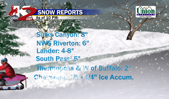
Casper, Riverton, Buffalo: 5-8"
Lander: 6-10"
Cheyenne: T-2"
Thermop: 4-6"
Sheridan: 6-9"


As always, we will wait and see IF the Models stay consistent with themselves AND show signs of Similarities with the Timing as they could blend together? 

Tuesday, October 22, 2013

10/22: SNOWTalk continues for early Next Week

Despite a Weak Clipper moving through Wednesday, overall not much to Discuss after an Amazing Tuesday with Highs in the Middle 60°s!  Ridge of High Pressure will continue to surge our Temperatures at or slightly above Average by Friday, so its looking pretty good.

Sunday Afternoon looks fine in the Upper 50°s and Dry Conditions, but conditions will slowly deteriorate during the late evening.  A lot of the Cold Air & Snow will stay put in Montana, but maybe a Flurry chance in the Northern Tier of WY.

LATEST Models from GFS show the Slower Progression of the Storm as it Organizes in Central WY; meaning, Upslope Snowfall likely. 

MONDAY AM:  The Evening GFS Run is a little Slower than the Morning EURO and here's what we are looking at: 

<< GFS shows Light to Moderate Snow breaking out in YNP/Absaroka's as a 1004mb Low forms near the Wasatch over UT.  

The GFS run shows a stronger Low than the EURO so that is something to keep an eye on; while our Cold Front impacts Central WY


MONDAY NOON:  The Low looks to stay at the same Intensity but becomes Broad in UT/CO Line.  Moderate Snow is possible in the Absaroka's as Central WY could experience some Light Snow or Flurry activity. 

-- EURO earlier today showed Heavier Snows in Bighorns, but Models still show inconsistent similarities and Intensities as it's still hard storm to Forecast.


MONDAY PM:  Now as we roll into the Evening Hours, our Low slides 'slowly' due East along I-70 in Colorado with the Upslope Effect in Central WY.  

<<  IF this is correct, expect a period of Moderate to HEAVY Snow possible in Central WY from Lander/Riverton & Casper and maybe Thermopolis area's.  

** This is what I was concerned as our Low could slow down and organize bringing that Heavy Snow threat along the 20/26 Corridor.  


-- Last Night, GFS had a nice banding along the Laramies, now it takes out that Chance with this evening's run.


TUESDAY AM:  The Colder Air wedging from the North to the South and a Broad Low in Colorado continues to show Moderate Snowfall in Central WY.  Could be another Big Snow for Casper as the Upslope continues. I am concerned how this Snow & Low is slowly Stalling and cycling which means the Snow could pile up fast.
** FINALLY, the EURO from this Morning is agreeing with the GFS of this Evening as the Upslope continues for Central WY

Now the I-90 Corridor can likely see some Nice Snowfall all the way to Rapid City and Black Hills area.  


TUESDAY PM:  As the Evening rolls around, we will likely see the Activity dissipate and shift to the East in the Plains as the Colder Air ushers in.  So for right Now, I am calling this storm a  ** System to Watch** 


THOUGHTS:  Storm is still now under a Week away and showing signs of something Big for a few right now in Central WY.  Heavy Snow is a potential as the Upslope component is there with some Jet Stream Dynamics is there with Cold Air in play.  Colorado is also a threat for some Moderate Snow but we will watch how the Models stay Consistent with each run and IF the Models show Similarities.

Monday, October 21, 2013

10/21: Tranquil Week leading to More SNOW??

Evening Folks,

Not much to talk about this week Weather Wise except Dry, Seasonal, and Sunny Conditions we could experience through the rest of the Week and Weekend?  A small Clipper on Wednesday in the Dakota's but that's about it. 
<< Nothing is worthy of Mentioning, except MONDAY. 

From 58° to 36°, SOMETHING has got to give right?  Cold Temps & Precip means one thing; so lets talk about what I am seeing.


SUNDAY PM:  Models earlier this Morning showed warmer Temps nearing 60 but the Cool down increased with the late evening Model.  A large amount of moisture with the Front is poised to drop South into Northern WY by late Evening with Light to Moderate Snow in YNP/Absaroka's as a 1008mb Low forms in Southwest WY and Utah providing some Upslope potential for the Mountains. (IMAGE BELOW)

MONDAY MORNING: By Morning, the Cold Air is in Place as the Snow could start falling in Central WY while Moderate-Heavy Snow is possible in the Absaroka's and Bighorns.  We will keep that broad 1008mb Low to the Southwest as it slowly shifts East into Western CO. (IMAGE BELOW)


MONDAY EVENING:  The Low to the South in CO strengthens once more to a 1004mb Low.  Lots of Moisture with this Storm as compared to the last few Systems after our Big Storm early October.  Moderate to Heavy Snow is possible from Central WY down to the Laramies so cities of impact are Riverton/Lander/Casper/Cheyenne.  Another Thing to discuss about this Storm is the COLD Air behind it as Temperatures could drop in the Teens behind the Snow. Note how the storm 'wedges' with that Cold Air?... a Mature Storm.   (IMAGE BELOW)

TUESDAY MORNING:  Moisture still lingers via GFS in Central WY & I-80 as the Storm continues to slide South in the Denver area and East in Nebraska.  Some Flurries could stay through Mid-Day but the system is still too far away to know.


THOUGHTS:  This system is still very early in the Making to know for sure 'HOW MUCH' Snow can fall, the Timing and Placement of the Storm Track, but the other Model (EUROPEAN) is Similar to the GFS Run from this Evening but shows not as Intense with the Snow for Central WY. 

** IF the EURO Model this Evening Follows suit with the GFS in Intensity, we will have to closely monitor on the Consistency of both Models as the Storm nears next Week **

Thursday, October 17, 2013

10/17: Let the SNOW Fall for Cheyenne!

Snow began to fall in Southeastern WY earlier this Afternoon and has continued to do so through the rest of the evening.  More snow will fall in the Overnight Hours as the Bulk of the Moisture should stick around for the morning rush and could linger as late as 9-11AM

Latest Radar scan shows the bulk of the activity in Southeast WY with many slick roads, as the snow showers will remain isolated in Central WY with lighter amounts of accumulations.


The Winter Weather Advisories will last through the Overnight for much of Southeastern WY 'til Daybreak on Friday.
HOW MUCH Can we expect out of this Storm?  No change on my Amounts from the earlier evening through the late evening Newscast.  So when all is said and done with, here are the Amounts what I am going with:

The newest Hi-Res Rapid Refresh Model is suggesting that another 3-6" could fall around the Cheyenne vicinity this evening but it all depends if the Bands will persist through the overnight hours. A "Newer" band of moisture is coming into Northern WY this evening that could drop 3-6" also into the Bighorns. Just not much moisture to work with along and East of the Laramies North of Cheyenne and Central WY.  This isn't really an Upslope Event.

Wednesday, October 16, 2013

10/16: CLIPPER is Approaching WY ~ SNOW AMOUNTS included

The CLIPPER I have mentioned in the past week is now sliding into Northern WY right now before the 11PM Hour:
It'll take a while for the Snow to fall in the Lower Elevations, but light snow is likely for the remainder of the Evening along and North of I-90.  We'll stay Dry and Cloudy for Central WY in the Upper 20°s/Lower 30°s for many of us through the Overnight.

THURSDAY AM:  The best Moisture content should stay in the Mountains but only light snow is expected. Just not enough 'juice' with this system so it'll breeze through WY pretty fast, just alot of cold and brisk winds. (IMAGE BELOW)

-- GFS shows a little more Moisture than NAM, but if there is anything, just some Flurries flying around.


THURSDAY NOON:  Moisture dries up through the late morning-Noon-and Early Afternoon Hours by many Models but the Colder Air will set in.  (SHOWN BELOW)


THURSDAY 6PM-Midnight: As we lead into the Evening Hours, the Temperatures will drop around the Freezing Mark and should turn from a brief Mix to ALL SNOW for Southeastern WY & Cheyenne.  The GFS (SHOWN BELOW) is a little aggressive for the Precip than the NAM Model, but expect some Flurries to fly around for Central WY as little to no accumulation is expected. 
 ** I-80 Could be a little impassable at times as the snow could fall at a fast clip through the Passes, so Safe Travels **


FRIDAY AM: Now, THIS is where it could get interesting. It all depends how long this piece of energy lasts through the I-80 Corridor.  Both Weather Models (GFS/NAM) shows different analysis for the Morning Commute and I'll show you both.


<< NAM is the "Quick-Hitter" with this Clipper leaving Cheyenne with Flurries and Northeast CO with some Moderate Snow potential.  

*  You can see a new round of Moisture increasing behind the previous storm as we could have more Flurries fly in the Black Hills and I-90 Corridor *


<< GFS could be 'over-done' with this Run for Friday Morning, but Cheyenne looks Snowy with Moderate Snowfall potential along I-80 from the Mountains to Pine Bluffs.


** The Rest of Friday looks Dry/Cool as Temperatures will slowly climb in the 40°s. **


WINTER WEATHER ADVISORIES are in effect for Southeastern WY but excluding Platte/Goshen Counties, where they can see much lesser amounts.

HOW MUCH SNOW??? I don't think much will fall in the Lower Elevations for Central WY; just like the previous system earlier this week.  The Bighorns & Laramies could see the Better Snow amounts as the storm is impacting the Bighorns right now. It'll reform Tomorrow Evening for the Laramies and could increase that Impact for Cheyenne area.


Before I conclude here, for the People concerned for the Cheyenne area, check this out.  Here is a Meteogram showing you the Range of Snow Amount in the City.  IFFFFF the Models take the GFS Track, expect a Higher Amount of Snow up to ~ 7-9"  So right now, I am calling for 2-5" for Cheyenne.


Tuesday, October 15, 2013

10/15: Snow "Clipper" Chances continue for Thursday

Our Snow System that is currently spinning around the Canadian Rockies in Alberta will slowly Migrate Southward in Montana on Wednesday. 
 WYOMING will remain Sunny, but Cool on Wednesday with High's still well below Average as our Storm tracks Southeast.  By late Evening, some parts of the Northern Tier of WY in the Mountains could experience some Light Snow but it depends on how dry our Atmosphere is cause that will take a while for the Snow to fall.

THURSDAY:  I am not anticipating any freak or panic Heavy Snow for the Lower Elevations as these Clipper Systems are usually a quick-hitter with light accumulations.  

<< THURSDAY AM:  Both GFS/NAM Models do show similar Precip Placement as our Clipper arrives along the Bighorns/Black Hills and I-90 Corridor with Light Snow.

(Light Accumulations Expected)


<< THURSDAY MID-DAY:  The Clipper slides into Central WY with a chance of a Mix for the Afternoon, but you can see just not much is there to work with for all you Snow Lovers to get excited about.


<< THURSDAY Evening-Overnight: 
**HERE is where it could get interesting. The air will cool as the evening progresses and the Snow could get pick up intensity along I-80 for Laramie & Cheyenne.


The NAM is a 'tad aggressive for this evening Snow than the GFS, but I think the slower the system moves, the better chance of Light Accumulations for Southeast WY


<< FRIDAY Morning:  Light Snow 'could' continue for Cheyenne area and also South around Denver, where they could see their 1st  Light Accumulations of the Year.  

-- NAM has the Snow diminishing, while the GFS (Shown Here) lingering through the Morning along I-80.  

PLUS, another piece of Energy from GFS shows another band of Flurries in Black Hills by Morning and exiting this activity by Mid-Day Friday.

SNOW AMOUNTS:  Right Now, I am not expecting Much in Central WY with this Snow...maybe a T-1" for Casper/Riverton/Lander and Few More Inches or so in Bighorns/Absaroka's.

I do think CHEYENNE could at least a Few Inches IF it takes the GFS & slower track.  The Meteogram (SHOWN BELOW) has a Range of 2-5" for the city and I'll keep an eye on this as we have one more evening to track this Clipper. Stay Warm, Folks!

Monday, October 14, 2013

10/14: It's CLIPPER Time! ~ New Storm arrives Late Week

After our Mess from Monday, we saw the Highest Snowfall Reports in the Mountains.  Reports of a Foot in the Bighorns and about a Half Foot or more on Casper Mountain.

Don't look too far ahead Folks!  SNOW is possible as we creep into Thursday.  This weather pattern is more like the Winter Time, not so Fall-Like. 
-- This Weather Feature arriving Thursday Morning in WY is known as an "Alberta Clipper. (SHOWN LEFT)

These Features form off the Canadian Rockies and drop from Alberta and surge Southeast into the Lower 48. 

* Blast of Cooler Air and Moisture will come with this; but a 'slight' warmup for Weekend.


BOTH Evening Runs show this Clipper arriving possibly late Wednesday Evening in the Northern Tier of WY, but Light Snow should increase in the Morning Hours on Thursday for the Bighorns & Absaroka's.

Still Dry but Cool for Central WY


<< GFS shows the Moisture arriving Central WY by Noon and lingering into the Bighorns, Abasaroka's as well.  

** However, the NAM (Not Shown) is a touch faster and a little more Southeast excluding the Riverton/Lander area.


<< By Thursday Evening, some Flurries will linger in the Mountains and Central WY, but Cheyenne could see that Light Snow fly around.


AMOUNTS Looks to be very Light with Little to No Accumulation for the Lower Elevations. If the System slows down, expect that chance for a Couple Inches. 

Sunday, October 13, 2013

10/13: SNOW Threat on Monday

Good late Sunday Folks,

Some have already experienced Rain this evening in Central WY and even some Light Snow reports from Dubois.  I do think we'll stay mostly 'warm' for plain Rain through the Evening as Overnight Hours.  However, our Colder Air will arrive by Dawn on Monday to transition our Snow/Mix Precipitation when we head out to work. 

I want to say that it could take a while for the Precip to changeover since there could be some Drier Air working in.

< Our Low Pressure (1008mb) is still a little weak, but will form off the Laramies and into Northeastern CO by Monday Morning and looking like the Bighorns and Absaroka's could experience Moderate Snow.  

Central WY could experience that Mix or Light Snow during the Commute to Work but we will see how much of the Precip will fill in.


<< NAM by 12PM Monday shows a stronger circulation at 1004mb in Western NE with Northwest Wind flow in Central WY wrapping around the Storm with Snow.  

Could be a decent Snow for Bighorns & Black Hills if the storm verifies the NAM, but the GFS is much weaker at Noon with a 1008mb Low and not as Fast.


Now I think we can continue the Light Snow/Flurries through 6PM in Central WY,  but the activity should diminish as Midnight Monday roles around.  Any snow should stay to the Northeast in the Black Hills as the Big Storm will be near Sioux Falls, SD.

TUESDAY:  NAM shows a few lingering Flurries, while the GFS stays Dry, but the day should stay Cool and Chilly.


HOW MUCH are we looking at?  Before the Amounts, here are the very latest Advisories in Wyoming in regards to the Storm
I am NOT expecting a Big Snow for Central WY in the Lower Elevations for the Basins, Wind Rivers, and Casper area.  
*1-3" I'm looking at for Riverton/Casper and locally more for South Casper and for Lander .
*  A Half-Foot or so on Casper Mtn and the Northern Laramies where over a Foot is expected in the Bighorns and possibly in the Black Hills.  

I Will Keep you Updated through the late Morning and all Afternoon on Monday with the Latest Updates.

-MS