After our Mess from Monday, we saw the Highest Snowfall Reports in the Mountains. Reports of a Foot in the Bighorns and about a Half Foot or more on Casper Mountain.
Don't look too far ahead Folks! SNOW is possible as we creep into Thursday. This weather pattern is more like the Winter Time, not so Fall-Like.
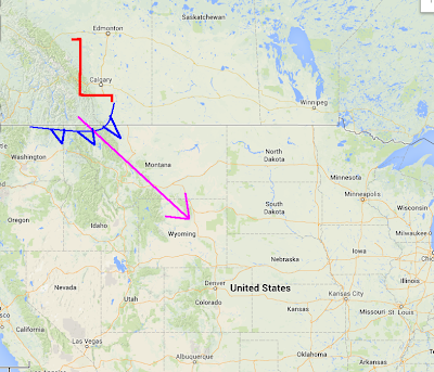
-- This Weather Feature arriving Thursday Morning in WY is known as an "Alberta Clipper. (SHOWN LEFT)
These Features form off the Canadian Rockies and drop from Alberta and surge Southeast into the Lower 48.
* Blast of Cooler Air and Moisture will come with this; but a 'slight' warmup for Weekend.
BOTH Evening Runs show this Clipper arriving possibly late Wednesday Evening in the Northern Tier of WY, but Light Snow should increase in the Morning Hours on Thursday for the Bighorns & Absaroka's.
Still Dry but Cool for Central WY
<< GFS shows the Moisture arriving Central WY by Noon and lingering into the Bighorns, Abasaroka's as well.
** However, the NAM (Not Shown) is a touch faster and a little more Southeast excluding the Riverton/Lander area.
<< By Thursday Evening, some Flurries will linger in the Mountains and Central WY, but Cheyenne could see that Light Snow fly around.
AMOUNTS Looks to be very Light with Little to No Accumulation for the Lower Elevations. If the System slows down, expect that chance for a Couple Inches.


No comments:
Post a Comment