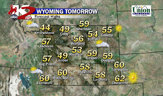
Before the Front pushed through today, the Southwest Flow increased our Temperatures at or a few degrees above Seasonal. Overall, not a bad Tuesday with some breezy conditions at times.
Slightly Cooler on your Wednesday as we'll keep the Clouds and that slight breeze as we'll stay mainly Dry for much of Central & Eastern WY.
<< Now I do have to say that Low from our Southwest will organize and surge some Jet Stream moisture into our Southwest late Afternoon and could lead a "Sprinkle Chance" in Central WY for the Evening and Overnight Hours.
THURSDAY: Our Low from the South surges into the Rockies through the day with Mountain Snow likely above 8000FT that could accumulate 5-10" or so in the Bighorns, Tetons, Wind River's. Plain RAIN for many of us in Central WY but cool Temperatures. Moisture should stick around all day so rain will be scattered
<< ALL MODELS are suggesting this Low to push East of WY and move into Nebraska and Dakota's. Severe Storms possible for the Plains with High Winds, Hail and maybe a Tornado or two.
By Late Thursday, the Cold Front will move West>East through the Overnight as some spots could see a brief Mix of Precip.
FRIDAY: Now as the Cool Air surges into Central WY, it all depends how much "moisture" there is to see if we receive any Frozen Precip by Morning through Mid-Day.
<< Just not much Precip to work with as the Cool Air really dries out Central WY. Maybe Casper Mtn could see some Light Snow or Wind Rivers, but all of the activity should taper off through the Afternoon and Early Evening.
LOOKING AHEAD: Quiet for Saturday and for much of Sunday before our next Storm Chance coming from the Northwest.
** Now I have to tell you all this: How far South our Front digs South will determine our Strength for our upcoming Storm; and I'll show you why **
GFS Track: As early as late Saturday, NW Wyoming could see some light snow. Sunday looks like the better day of Light to Moderate Snow for Northern Tier of the State but not enough moisture for Central WY (Riverton/Casper, etc). Late Sunday does show some light snow for many of us in the State as the Cool Front slides in; also including Cheyenne area.
<< Not much organization with this as a Low is not so apparent to provide the Upslope Snow energy. Though the Mountains can likely see some decent Accumulations.
EUROPEAN Track: Now, the last Weekend Storm was handled well from this Model. AND, once again, this model shows a unique track with more organization and lifting energy with a Low Forming in Colorado for Upslope. Another thing about the EURO Track is that its Slower than the GFS. The Cooler Air here will Dig the Low and swing it around CO and Western WY as it sets up in Eastern CO by Monday Evening.
<< You Can clearly see the Wind Barbs show that wrap around Moisture of a deep Low forming in CO. Plus like I mentioned above, the Low is slower and better organized as compared to the GFS. Monday could be a Snowy start to the Workweek if this follows suit. PLUS, the Canadian Model phased this way too to bring a Snow Potential.
THOUGHTS: A Lot to talk about in a span of a Week. Storms are lining up and could be a Stormy/Snowy October. We'll see how the Models play out late this evening and Tomorrow.
Same Bat Time, Same Bat Channel
MS


No comments:
Post a Comment