Happy 'Cool' Wednesday Folks,
Temperatures were well below Normal for many of us in the 50°s, but our Cool Temperatures will continue on Thursday but moisture will increase in the Afternoon.
Highs should stay in the 50°s for many of us and maybe a couple 60°s East of the Laramies.
Talk about 'Scattered' for Thursday as some spots will stay wet through the day and good soaking rains near the Foothills?
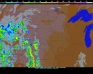
<< NAM HI-RES shows widely scattered showers all over WY. Mountain Snow should break out in the Higher Elevations and on the Warmer side, maybe a line of storms late afternoon/Evening in Western KS/NE.
<< Storm Prediction has issued a Slight Risk for that Line of Storms developing on Thrusday and does include a slither of Goshen/Niobrara Counties, but I think the best moisture, lift, dynamics will stay to the East.
Hail, High Winds, and maybe a Tornado or Two looks like the main threats.
And..there is a SNOW Side to it. Much of Central WY and the Lower Elevations will stay warm enough for plain 'ole rain showers. The Mountains will likely see the Snow Threat:
FRIDAY MORNING: Our tightly wound up Low in the Dakota's will be ahead of the Cold Front pushing through WY. Mountain Snow will continue and if there is enough moisture as that Front pushes East, a quick shot of Frozen Precip is possible. Luckily little to no Accumulation is expected.
SATURDAY & Early Sunday: Looking quite Sunny, but Cool so the Tailgating Festivities in Laramie for the 'Pokes game is a go at 1:30PM as they play New Mexico at War Memorial.
SUNDAY: Our next Storm system will slide in from the Northwest, but both the EURO and GFS Models show completely different analysis. Lets show the GFS Model run from this Morning first off:
<< Our Cool Front is set to slide in by Sunday Evening with Light Snow breaking out in Western WY and Flurries for the Bighorns. Quite dry in Casper but not much of organization with this Model.
<< GFS by Monday Morning shows a "Dis-discombobulated" Activity in WY as Flurries will fly around WY. Its a quick hitter for WY as the System races East in the Plains.
NOW, Lets get to the European Model which is more organized and slows down our Storm.
<< EURO Model by Sunday Evening shows a Low developing in UT/CO spreading Moisture and Snow in Western WY & Bighorns.
Like I have mentioned countless of times, if you want that Snow, make sure your Low is to your South. Its that upslope effect with winds blowing from the North and Northeast..
<< As we get to Monday Mid-Day, a 1008mb Low forms in Eastern CO. You can see the snow wrapping around the Low and Light Snow could persist several Hours for Central WY and Light to Moderate Snow breaking out in the Mountains.
THOUGHTS: As always, still too early to tell how these Two Models will persist through the days ahead. I want to suggest that the EURO Model handled our last Storm fairly consistent and accurate where the storm track would be and the duration of the event. Wait and see how the Thursday Models stack up!


No comments:
Post a Comment