Our Storm is on track to continue stay in Eastern UT providing better Snow Amounts for Western WY this Evening. PLUS, some Moisture could linger on the Eastern side of the state for a Freezing Drizzle possible.

<< ALL Winter Weather Advisories (Purple) will expire at 9AM Tuesday
<< Freezing Rain Advisory for the Laramies will expire at 9AM as well.
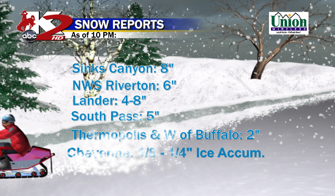
RIVERTON & LANDER has won the Snow Amounts so far with this System as much of the Snow fell this Morning as the Front pushed through. Here are the Totals as of 10PM:

* We Will see how much is Possible through Tuesday as periods of Rain & Snow will continue for much of WY.
TUESDAY PM: A Streaking band of Moisture will develop in Cheyenne area which could lead to a round of Light Snow or a Mix as the System travels North and East leaving many Cool & Dry
NEXT STORM...?
As we leave this System behind, remaining Cool & Dry as I mentioned also for Halloween but slightly warmer for late Week.
Now for Late Week, a Cool Front will sag into WY once again and a ripple effect in the Rockies could provide some Snow?

<< GFS & EURO both show this by late Sunday or Monday but are both off on the Timing by 12 Hours.
Tonight's GFS Run didn't show this Feature but we will watch this if it keeps popping up from Now through the Week.
** Do Not Take this Storm with a Grain of Salt**
No comments:
Post a Comment