Last time to Talk about this Storm as the whole "sh-baam" will fully get its act together early Thursday and last through Friday.
THURSDAY: Dropping of the Temperatures likely as moisture will really increase through much of Central & Western WY as Cooler Air will set in. Cold Rain likely for many in the cities, while the Mountains will continue that Light to Moderate Snow through the early Afternoon.
** I Have been Hinting the Potential of MAJOR Accumulations for many, but here are the Cities that could likely see over a Half-Foot or More in WY. If your prone to the Mountains & Upslope expect Double-Digit and a Foot **
THURSDAY PM: Our Futurecast (SHOWN BELOW) by 7PM is showing that Colder Air working in changing that Cold Rain to Snow potentially in the Wind Rivers and much of the Mountains. Along and East of I-25 is still Rain but won't be long for Casper. I think it'll turn to ALL SNOW for the city between 7-9PM. You can also note how our Low is slowly developing to our South in CO. This will provide the Upslope effect with Northeast Winds... Could be a little breezy at times in the wind prone areas.
MIDNIGHT THURSDAY: As you see, our Low stays to the South along that Boundary and could see a Northerly wind flow component from latest Upper Air Soundings..meaning the Snow could pile up fast on the Foothills, esp for CASPER. Much of WY should see ALL SNOW including the I-90 Corridor and Along and West of I-25. I do think the Temperatures will be just a little above Freezing so Cold Rain for Cheyenne area.
FRIDAY MORNING: Folks, I do think Travel will be treacherous if your heading to work or out of town, since its a big night for Football Games, too. MODERATE - HEAVY Snow is likely for much of WY that some Roads and Highway's might be closed; so check with WYDOT for the Latest. Our Low still stays put, but you'll see how fast the Low will shift Northeast through Friday.
MID-DAY FRIDAY: SNOW still pounds much of Central & Eastern WY as the Low slowly slides Northeast nearing NE Colorado. Snow could taper off in Western WY as the Low moves East and we will watch the progression of this track.
-- Heavy Snow potential as well in Western SD/NE around the Black Hills too, so the travel along I-90 will be impacted likely.
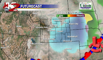
FRIDAY EVENING: Light to Moderate Snow can still continue along and East of I-25 as the Low tracks toward KS/NE with a Severe Storm threat in the Plains! IF YOU want to follow the Severe Side, my Colleague out in the Field, Josh Alecci "WYOStormChaser" will be out chasing the Storms in Iowa.
HERE is the Link if you want to follow on Facebook: WYO STORMCHASER &WXSCOPE
By this Time, the snow will be light from the Bighorn Basin to Riverton and points West.
LATEST THOUGHTS: The Models still disagree at times on where to place the Low from Friday Morning to Evening. Plus the SPEED makes an impact. Longer the Low stays in CO, expect Heavy Snow in your Area. If it races East toward KS/NE, expect not so much. Have a great Evening or Early Morning and will bring you the very latest on Thursday!
-MS


No comments:
Post a Comment