HAPPY OCTOBER Folks!
Personally, this is one my most Favorite months of the Year. Leaves change, Temperatures cool down, and Bonfires to warm you up!
Lets get down to Business, cause there is a Copious amount of new data coming in that could be Historic if we talk about SNOW AMOUNTS.
WEDNESDAY: A cool day in the Lower 60°s for many as a weak piece of energy slides in with Jet Stream Energy from the Southwest working through. Could see Snow Chances for parts of Western WY increase later that evening as a Low will develop to our Southwest in UT.
Overall the 1st Half of Wednesday will look nice and sunny but slightly below average Temperatures.
<< BOTH Models (NAM/GFS) show this feature developing with Jet Stream energy increasing providing Snow Chances for Western WY by late Wednesday Evening..maybe that "Rain" chance for parts of Central WY.
THURSDAY: It'll be a very Cool afternoon and I think Highs will climb slowly in the Lower 50°s for many spots and maybe 40°s too as Moisture will increase from the North & West ushering Cooler Air with it. SNOW Will begin to break out for Western & Northern WY in the Mountains, and maybe a 'chance' of some Rain in Central WY~ Cold Rain too.
<< This is by NOON Thursday from the GFS showing Low Level Energy beginning to develop to our South and and Easterly wind direction forming..UPSLOPE Wind Alert
Snow should break out for the Mountains to the Northwest with Light to Moderate Intensity.
-- GFS shows Rain chance for Central WY, but NAM says Dry.
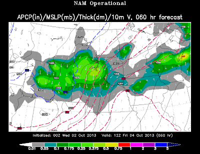
THURSDAY 6PM: Now this Evening, the GFS has stayed consistent from last night's and this mornings run, even this evening for the new Low Placement. However, the NAM was North into SE Wyoming showing Big Snows for I-90. However, BIG Change. (IMAGE BELOW) Now, the NAM shows a deep 1000mb Low in NE Colorado. This is the placement where you want deep snow for the Laramies/Central WY.
<< NAM shows Moderate/Heavy Precip of a Mix to All Snow in Central WY, including the Bighorns.
The Wrap-Around Flow shows the Upslope Effect with a Northeast Wind Component.
**GFS showed Moderate Precip too; including the EURO & Canadian Run too from this Evening.
MIDNIGHT THURSDAY: The Low in CO continues to pump in Moisture, Cold Air wrapping around and Moderate to Heavy Snowfall from Central WY, Bighorns, & along the Laramies.
**TRAVEL** could be very treacherous at this time so you may want to monitor WYDOT for all the Closures.
<< GFS shows that Large/Broad Low Pressure in CO and NAM follows Suit.
-- Likewise, the Canadian & European Models like this placement of the Low too, so the Snow Storm is a GO.
FRIDAY AM: Systems still show Moderate to Heavy (at times) snow for Central WY but the placement gets a little tricky. The GFS likes the Southeast in Cheyenne to see big snow, but the NAM is showing differently and a little North.
<< NAM shows BIG SNOW along the I-90 Corridor towards Rapid City and Continuing farther South on I-25 in Casper by Morning.
-- You can note how the Low has slid East now into Eastern NE/KS.
FRIDAY PM: Still, we are watching Inconsistency with the models by Friday Evening..during the HS Football games too! Could be a SNOWY & COLD ball game for the players and fans..Bundle Up!
*NAM: The NAM takes this Storm way East and pushes all the Snow in SD/NE and dries out WY
*GFS: The GFS continues with Light Snow from Casper and points East through 6PM and dries out by Midnight.
*CANADIAN (GEM): You can't forget about the Canadian Model since its nice to see Winter Systems with a Colder Airmass. They actually show SNOW (Light to Moderate) in Central & Eastern WY
* EURO: Here the EURO shows Light to Moderate snow continuing through Early Evening on Friday in Central & Eastern WY.
<< EURO by Midnight Friday continues to 'SLOW' down meaning the Storm still gets stronger and better organized. Accumulation will likely to pile up.
SATURDAY MORNING: Now, last evening if you were reading, I said how the Snow should taper off and dry out? Well...a different story is slowly developing. Both the EURO & Canadian show a 'slower' pattern through the Overnight on Friday and into Saturday Morning.
<< EURO still shows Light Snow from Casper and points East and the Canadian is very similar.
SNOW AMOUNTS: Before I show you this Image, the Storm is "capable of being a historic on record". A Crippling Storm since we still have leaves on the trees and could cause MORE Tree Damage & Power Outages. Lots of Moisture with this storm as it shows OVER and Inch of Precip and mainly 1.5"-2" ... Yes, there will be some rainfall involved, but that changeover to Snow will transition fast.
- This is from the NAM Model Run. This is NOT my forecast, but I want to show you the "worse case" scenario from what this model showed this evening.
<< NAM shows Insane amounts of Snow for Central WY!!
Here's what its showing:
Casper/Riverton/Lander: 12" +
Sheridan/Buffalo: 6-12"
NEWEST Data from the GFS is showing lesser amounts but still quite High for Central & Southeast WY.
THOUGHTS: Time to start gathering a plan if power does go out in your area. I do think from Thursday Evening through Friday will be the worse of the Event, but IF the two models (EURO/Canadia) continue to last through Friday Evening and Morning Sautrday...could be a Historic Storm for Central & Eastern WY.


No comments:
Post a Comment