Despite a Weak Clipper moving through Wednesday, overall not much to Discuss after an Amazing Tuesday with Highs in the Middle 60°s! Ridge of High Pressure will continue to surge our Temperatures at or slightly above Average by Friday, so its looking pretty good.
Sunday Afternoon looks fine in the Upper 50°s and Dry Conditions, but conditions will slowly deteriorate during the late evening. A lot of the Cold Air & Snow will stay put in Montana, but maybe a Flurry chance in the Northern Tier of WY.
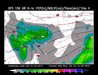
LATEST Models from GFS show the Slower Progression of the Storm as it Organizes in Central WY; meaning, Upslope Snowfall likely.
MONDAY AM: The Evening GFS Run is a little Slower than the Morning EURO and here's what we are looking at:
<< GFS shows Light to Moderate Snow breaking out in YNP/Absaroka's as a 1004mb Low forms near the Wasatch over UT.
The GFS run shows a stronger Low than the EURO so that is something to keep an eye on; while our Cold Front impacts Central WY
MONDAY NOON: The Low looks to stay at the same Intensity but becomes Broad in UT/CO Line. Moderate Snow is possible in the Absaroka's as Central WY could experience some Light Snow or Flurry activity.
-- EURO earlier today showed Heavier Snows in Bighorns, but Models still show inconsistent similarities and Intensities as it's still hard storm to Forecast.
MONDAY PM: Now as we roll into the Evening Hours, our Low slides 'slowly' due East along I-70 in Colorado with the Upslope Effect in Central WY.
<< IF this is correct, expect a period of Moderate to HEAVY Snow possible in Central WY from Lander/Riverton & Casper and maybe Thermopolis area's.
** This is what I was concerned as our Low could slow down and organize bringing that Heavy Snow threat along the 20/26 Corridor.
-- Last Night, GFS had a nice banding along the Laramies, now it takes out that Chance with this evening's run.
TUESDAY AM: The Colder Air wedging from the North to the South and a Broad Low in Colorado continues to show Moderate Snowfall in Central WY. Could be another Big Snow for Casper as the Upslope continues. I am concerned how this Snow & Low is slowly Stalling and cycling which means the Snow could pile up fast.
** FINALLY, the EURO from this Morning is agreeing with the GFS of this Evening as the Upslope continues for Central WY
Now the I-90 Corridor can likely see some Nice Snowfall all the way to Rapid City and Black Hills area.
TUESDAY PM: As the Evening rolls around, we will likely see the Activity dissipate and shift to the East in the Plains as the Colder Air ushers in. So for right Now, I am calling this storm a ** System to Watch**
THOUGHTS: Storm is still now under a Week away and showing signs of something Big for a few right now in Central WY. Heavy Snow is a potential as the Upslope component is there with some Jet Stream Dynamics is there with Cold Air in play. Colorado is also a threat for some Moderate Snow but we will watch how the Models stay Consistent with each run and IF the Models show Similarities.


No comments:
Post a Comment