Our Snow System that is currently spinning around the Canadian Rockies in Alberta will slowly Migrate Southward in Montana on Wednesday.
WYOMING will remain Sunny, but Cool on Wednesday with High's still well below Average as our Storm tracks Southeast. By late Evening, some parts of the Northern Tier of WY in the Mountains could experience some Light Snow but it depends on how dry our Atmosphere is cause that will take a while for the Snow to fall.
THURSDAY: I am not anticipating any freak or panic Heavy Snow for the Lower Elevations as these Clipper Systems are usually a quick-hitter with light accumulations.
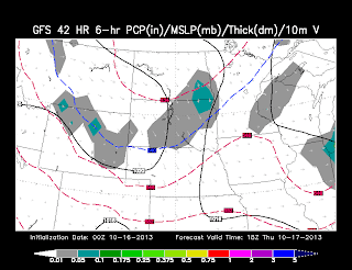
<< THURSDAY AM: Both GFS/NAM Models do show similar Precip Placement as our Clipper arrives along the Bighorns/Black Hills and I-90 Corridor with Light Snow.
(Light Accumulations Expected)
<< THURSDAY MID-DAY: The Clipper slides into Central WY with a chance of a Mix for the Afternoon, but you can see just not much is there to work with for all you Snow Lovers to get excited about.
<< THURSDAY Evening-Overnight:
**HERE is where it could get interesting. The air will cool as the evening progresses and the Snow could get pick up intensity along I-80 for Laramie & Cheyenne.
The NAM is a 'tad aggressive for this evening Snow than the GFS, but I think the slower the system moves, the better chance of Light Accumulations for Southeast WY
<< FRIDAY Morning: Light Snow 'could' continue for Cheyenne area and also South around Denver, where they could see their 1st Light Accumulations of the Year.
-- NAM has the Snow diminishing, while the GFS (Shown Here) lingering through the Morning along I-80.
PLUS, another piece of Energy from GFS shows another band of Flurries in Black Hills by Morning and exiting this activity by Mid-Day Friday.
SNOW AMOUNTS: Right Now, I am not expecting Much in Central WY with this Snow...maybe a T-1" for Casper/Riverton/Lander and Few More Inches or so in Bighorns/Absaroka's.
I do think CHEYENNE could at least a Few Inches IF it takes the GFS & slower track. The Meteogram (SHOWN BELOW) has a Range of 2-5" for the city and I'll keep an eye on this as we have one more evening to track this Clipper. Stay Warm, Folks!


No comments:
Post a Comment